Medieval maps
Maps made in the Middle Ages, such as mappae mundi and portolan charts, and historical maps of the medieval world: Europe after the fall of Rome, Charlemagne's empire, the Crusades and the Holy Roman Empire.
Why they are free to use: Most were published more than a century ago, so their copyright has expired. Each map's page shows its own licence basis and a credit line.
Mappae mundi
Search “medieval mappa mundi world map” for more, or ask Claude for it

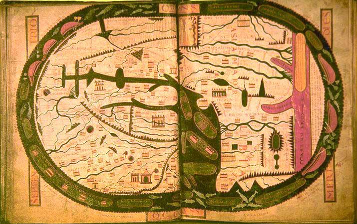
Ravenna mappa mundi, c.650
1898 · Wikimedia Commons

Hereford Mappa Mundi Detail Africa
1280 · Wikimedia Commons

Mappemonde-Liber-floridus-BNF-fo-45
1260 · Wikimedia Commons
World map.
Wikimedia Commons

Ca. 1277 World Map
1277 · Wikimedia Commons

A map of the world - Latin Psalter (13th-15th C), f.9 - BL Add MS 28681
Wikimedia Commons

Cotton world map
Wikimedia Commons

Abbo of Fleury, Map of the world
1833 · Wikimedia Commons
Portolan charts
Search “portolan chart of the Mediterranean” for more, or ask Claude for it

Portolan chart of the Mediterranean Sea, the North Atlantic Ocean, the Black Sea, and the northwestern African coast.Attributed to the circle of Vesconte Maggiolo
c. 1550 · Wikimedia Commons

Portolan chart of the Mediterranean and connecting seas.
1550 · Library of Congress

Nautical chart of the Mediterranean area, including Europe with British Isles and part of Scandinavia. HM 1548. anonymous, PORTOLAN CHART (Italy, 15th century).I
1492 · Wikimedia Commons

(Portolan chart of the Mediterranean and Black Seas with the west coast of Spain and Portugal)
1575 · Library of Congress

Portolan Mediterranean Sea ca 1600
c. 1600 · Wikimedia Commons

Nautical chart of the Mediterranean area, including Europe with British Isles and part of Scandinavia. HM 1548. anonymous, PORTOLAN CHART (Italy, 15th century).M
1492 · Wikimedia Commons

(Portolan chart of the Mediterranean, the Black Sea, and the coasts of Europe and northwest Africa).
Library of Congress

(Portolan chart of the Mediterranean Sea and western part of the Black Sea); (Portolan chart of the Aegean Sea and part of the Mediterranean Sea including Crete)
1640 · Library of Congress
Charlemagne's empire
Search “historical map of the empire of Charlemagne” for more, or ask Claude for it

C. 814 Frankish Kingdoms
c. 1911 · Wikimedia Commons

Growth of Frankish Power, 481-814
1926 · Wikimedia Commons

F. W. Putzgers Historischer Schul-Atlas
3 sheets

RomanEmpire
1900 · Wikimedia Commons

Roman Empire full map
Wikimedia Commons

Roman Empire at the time of Emperor Constantine the Great, AD 306–337
1865 · Wikimedia Commons

Duchy of the Franks around 800
1895 · Wikimedia Commons

An historical map of Roman Empire and the neighbouring barbarous nations to the year of our Lord four hundred, when the empire began to be rent with foreign invasions. /. by Monsieur William Del Isle,
c. 1736 · New York Public Library
The Crusades
Search “map of the Crusades and the crusader states” for more, or ask Claude for it

C. 1140 Asia Minor and Crusader States
c. 1911 · Wikimedia Commons

C. 1097 Europe and Mediterranean Lands
c. 1911 · Wikimedia Commons

Asia Minor and the States of the Crusaders
1911 · 2 sheets

F.W. Putzgers Historischer Schul-Atlas: zur alten, mittleren und neuen Geschichte: in 66 Haupt- und 63 Nebenkarten
Wikimedia Commons

MACCOUN(1899) p195 66 A.D.-73 A.D. PALESTINE, TIME OF THE FINAL WAR WITH ROME
1899 · Wikimedia Commons

EB1911 - Map - Fig. 21.—Map illustrating Marino Sanuto’s Liber secretorum fidelium crucis
1911 · Wikimedia Commons

Palestine in the time of Jesus, 4 B.C. - 30 A.D. - (including the period of Herod, 40 - 4 B.C.)
1912 · Library of Congress
Medieval Europe
Search “historical map of Europe in the Middle Ages” for more, or ask Claude for it

C. 1190 Europe and Mediterranean Lands
c. 1911 · Wikimedia Commons

C. 1360 Europe and Western Asia
c. 1911 · Wikimedia Commons

Liber floridus, Map of Europe
Wikimedia Commons

C. 1254 Holy Roman Empire
c. 1911 · Wikimedia Commons

Nautical chart of the Mediterranean area, including Europe with British Isles and part of Scandinavia. HM 1548. anonymous, PORTOLAN CHART (Italy, 15th century).A
1492 · Wikimedia Commons

C. 1378 Central Europe
c. 1911 · Wikimedia Commons

Nautical chart of the Mediterranean area, including Europe with British Isles and part of Scandinavia. HM 1548. anonymous, PORTOLAN CHART (Italy, 15th century).P
1492 · Wikimedia Commons

F.W. Putzgers Historischer Schul-Atlas: zur alten, mittleren und neuen Geschichte: in 66 Haupt- und 63 Nebenkarten
Wikimedia Commons
Need maps for a video, lesson or book?
Add Find Any Map to Claude and ask for the maps you need, part by part. Claude searches this index, shows you the matches with their licences and writes the credit lines.
Add to Claude for free