Maps of the Roman Empire
Maps of ancient Rome and its empire from old historical atlases such as William R. Shepherd's Historical Atlas (1911) and Putzger's Historischer Schul-Atlas: the Republic, the Empire at its greatest extent under Trajan, its provinces, roads and frontiers, and the empire's division into East and West.
Why they are free to use: Most were published more than a century ago, so their copyright has expired. Each map's page shows its own licence basis and a credit line.
The Empire at its height
Search “map of the Roman Empire at its greatest extent under Trajan” for more, or ask Claude for it

Roman Empire full map
Wikimedia Commons

Roman Empire
1907 · Wikimedia Commons

Roman empire at its greatest extent
1856 · Wikimedia Commons
The Roman Republic
Search “map of the Roman Republic and its conquests” for more, or ask Claude for it

1923 rome-expansion-shepherd-historical-atlas-enhanced 1-600x472
c. 1923 · Wikimedia Commons

Map of Republican Rome by William R Shepherd (died 1934) edited
1934 · Wikimedia Commons

Map of of the Roman Empire, from the Small Brockhaus and Efron Encyclopedic Dictionary, 2nd ed., vol. 2, book 4, between columns 1200 and 1201 (pages in file: 78-79).
1909 · Wikimedia Commons

Roman Mediterranean
August 20, 1956 · Wikimedia Commons

Roman empire 1st cen 1884
1884 · Wikimedia Commons

RomanEmpire
1900 · Wikimedia Commons

Rome expansion
1923 · Wikimedia Commons

The Growth of Roman Power in Italy Historical Atlas by William R. Shepherd, 1911. Courtesy of the University of Texas Libraries, The University of Texas at Austin. From The Historical Atlas by William
March 7, 2008 · Wikimedia Commons
Roman Britain
Search “map of Roman Britain” for more, or ask Claude for it

Map of Roman Britain (Johnston)
1888–1897 · Wikimedia Commons

print, book-illustration, map
1658 · Wikimedia Commons
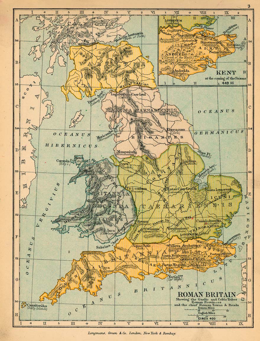
Roman britain 400
1905 · Wikimedia Commons

C. 410 Britannia
c. 1911 · Wikimedia Commons

A color map (335×400 cm) from Charles Bertram's forged account The Description of Britain (Latin: De Situ Britanniae). Text: Mappa Britanniae Facie i Romanae Secundum Fidem Monumentorum Pervertum Depi
1755 · Wikimedia Commons

BRITANNIA PROVINCIA ROMANORUM
2 sheets

Roman Britain (Droysen)
1886 · Wikimedia Commons

Roman Britain
1902 · Wikimedia Commons
Roman Gaul and the provinces
Search “map of the provinces of the Roman Empire, Gaul and Hispania” for more, or ask Claude for it

Roman province of Hispania
1886 · Wikimedia Commons

Europe Tabula II
1426 · Wikimedia Commons

Secunda Europae Tabula
1511 · Wikimedia Commons

Map of Roman Gaul in Swedish
1927 · Wikimedia Commons

C. 395 Roman Provinces
c. 1911 · Wikimedia Commons

Secunda Europe Tabula
1478 · Wikimedia Commons

Orbis Romani Pars Occidentalis Auspiciis Serenissimi Principis Ludovici Philippi Aurelianorum Ducis publici juris facta / auctor d'Anville Regiae Humaniorum Litterarum Academiae et Scientarum Petropolitanae Socius MDCCLXIII; G. de la Haye
1763–1764 · Wikimedia Commons

Secunda Europae Tabula
1511 · Wikimedia Commons
Roman roads
Search “map of Roman roads and the Peutinger table” for more, or ask Claude for it

1888 Konrad Miller edition of the Tabula Peutingeriana (NLA) composed
1888 · Wikimedia Commons

1888 Konrad Miller edition of the Tabula Peutingeriana (NLA) Sheet 06
1888 · 2 sheets

1888 Konrad Miller edition of the Tabula Peutingeriana (NLA) Sheet 08
1888 · 2 sheets

Roads in the Roman Empire
June 8, 2025 · Wikimedia Commons
The fall of the Western Empire
Search “map of the Roman Empire divided into East and West, barbarian invasions” for more, or ask Claude for it

An historical map of Roman Empire and the neighbouring barbarous nations to the year of our Lord four hundred, when the empire began to be rent with foreign invasions. /. by Monsieur William Del Isle,
c. 1736 · New York Public Library

An historical map of Roman Empire and the neighbouring barbarous nations to the year of our Lord four hundred, when the empire began to be rent with foreign invasions.
1736 · New York Public Library

C. 450 Roman and Hun Empires
c. 1911 · Wikimedia Commons

450 roman-hunnic-empire 1764x1116
1911 · Wikimedia Commons

The Historical Theater in the Year 400 AD, in Which Both Romans and Barbarians Resided Side by Side in the Eastern Part of the Roman Empire
Wikimedia Commons

The Roman Empire from Diocletian to the death of Theodosius (285-395 A.D.)
1902 · Wikimedia Commons

The Roman Empire ca 400 AD
October 31, 2007 · Wikimedia Commons

The Roman Empire after its division into the Eastern and the Western Empires (AD 395)
1874 · Wikimedia Commons
Need maps for a video, lesson or book?
Add Find Any Map to Claude and ask for the maps you need, part by part. Claude searches this index, shows you the matches with their licences and writes the credit lines.
Add to Claude for free