World War 2 maps
Maps of the Second World War made by the US government: the Twelfth Army Group's daily situation maps of the campaign in Europe, maps of the Normandy landings, the war in the Pacific, and the maps printed for the home front.
Why they are free to use: US government works (US Army, OSS, OWI) are not protected by copyright in the US. Each map's page shows its own licence basis and a credit line.
D-Day and Normandy
Search “map of the Normandy invasion D-Day June 1944 beaches” for more, or ask Claude for it

D-Day the 6th of June - Normandy 1944
1944 · Library of Congress

Newsmap Monday June 12, 1944 - map showing the Normandy landings
June 12, 1944 · Wikimedia Commons

(June 6, 1944), HQ Twelfth Army Group situation map.
June 6, 1944 · Library of Congress

Newsmap Monday June 12, 1944 showing the Normandy landings
June 12, 1944 · Wikimedia Commons

(June 7, 1944), HQ Twelfth Army Group situation map.
June 7, 1944 · Library of Congress

(June 8, 1944), HQ Twelfth Army Group situation map.
June 8, 1944 · Library of Congress
Situation maps of Europe
Search “situation map of the Allied front in Europe 1944 1945” for more, or ask Claude for it

(March 15, 1945), HQ Twelfth Army Group situation map.
March 15, 1945 · Library of Congress

(January 24, 1945), HQ Twelfth Army Group situation map.
January 24, 1945 · Library of Congress

(March 1, 1945), HQ Twelfth Army Group situation map.
March 1, 1945 · Library of Congress

(March 4, 1945), HQ Twelfth Army Group situation map.
March 4, 1945 · Library of Congress

(March 5, 1945), HQ Twelfth Army Group situation map.
March 5, 1945 · Library of Congress

(March 6, 1945), HQ Twelfth Army Group situation map.
March 6, 1945 · Library of Congress

(February 3, 1945), HQ Twelfth Army Group situation map.
February 3, 1945 · Library of Congress

(February 15, 1945), HQ Twelfth Army Group situation map.
February 15, 1945 · Library of Congress
The war in the Pacific
Search “map of the war in the Pacific islands 1942 1945” for more, or ask Claude for it

Pacific War - Micronesia, Melanesia and New Guinea 1941-42 - Map
1941 · Wikimedia Commons

Central pacific wwII
1945 · Wikimedia Commons

The World War II Pacific Theater as it appeared in August, 1942.
1942 · Wikimedia Commons

Pacific & Adjacent areas 1942 CMH Pub 72-22
1942 · Wikimedia Commons

Map of the Pacific Ocean and Far East, 1943
July 26, 1943 · Wikimedia Commons

Pacific War - Guadalcanal Campaign 1942 - Map
1942 · Wikimedia Commons

UP THE SLOT: Marines in the Central Solomons
1942 · Wikimedia Commons

Carrier warfare in Pacific 1941-42
1941 · Wikimedia Commons
North Africa and Italy
Search “map of the campaign in North Africa and Italy 1943” for more, or ask Claude for it

1943 Army Orientation Course Newsmap of the Mediterranean Sea and North Africa
1943 · Wikimedia Commons
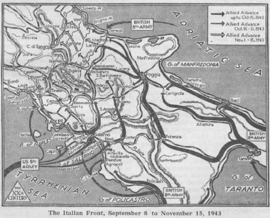
ItalienFront-Sep-Nov43 XXthCent
1944 · Wikimedia Commons

Italy - Special strategic map.
1943 · Library of Congress

ItalienFront-Sommer44 XXthCent
1944 · Wikimedia Commons

Campaigns of the 45th Infantry Division - (Europe).
1945 · 6 sheets

Mediterranean Area Map
1947 · Wikimedia Commons

Italy hopes war will bring new Roman Empire, 1940
June 2, 1940 · Wikimedia Commons

World War II Map - 1 - The Mediterranean
1944 · Wikimedia Commons
Need photographs too? See World War 2 photos on Find Any Photo, our search of public-domain archive photographs.
Need maps for a video, lesson or book?
Add Find Any Map to Claude and ask for the maps you need, part by part. Claude searches this index, shows you the matches with their licences and writes the credit lines.
Add to Claude for free