Old maps of New York City
Maps of New York City from the Dutch town of New Amsterdam to the 1920s: Manhattan before and after the Commissioners' Plan of 1811 laid out its grid, Brooklyn, bird's-eye views, and the insurance and real estate atlases that show the city block by block.
Why they are free to use: Most were published more than a century ago, so their copyright has expired. Each map's page shows its own licence basis and a credit line.
Manhattan
Search “old map of Manhattan New York City” for more, or ask Claude for it

Detail showing lower Manhattan in 1639 taken from a map by Joan Vinckeboons called "Manatvs gelegen op de Noot Riuier" (18 x 26.5 inches, pen and watercolor, held by the of the )
1639 · Library of Congress

A plan of the city and environs of New York in North America.
1776 · Library of Congress

City of New-York
1834 · Library of Congress

A plan of the city of New York from an actual survey, anno Domini, M D CC,LV by F. Maerschalck, city survey o r
1755 · Library of Congress

Map of City of New York published in 1834
1834 · Library of Congress

NYC Manhattan Topo Land Use 1865 Water Front South Streets (LCN g3804n.ct002003)
1865 · Library of Congress

Topographical map of the city and county of New-York, and the adjacent country - with views in the border of the principal buildings, and interesting scenery of the island.
1836 · Library of Congress

A plan of the city of New York from an actual survey, anno Domini, M(D)CC,LV
1755 · Library of Congress
New Amsterdam and colonial New York
Search “map of New Amsterdam and colonial New York” for more, or ask Claude for it

Nieuw Amsterdam op t Eylant Manhattans (translation: New Amsterdam on the island Manhattan.) From the inset by Nicholaes Visscher: Novi Belgii Novæque Angliæ, Amsterdam 1685 (Detail) The inscription reads in old Dutch A) The Fort B) The Church C) The Windmill D) The flag that goes up when new ships
c. 1685 · Library of Congress

Manatvs gelegen op de Noot (sic) Riuier.
1639 · Library of Congress

Manuscript. Pen-and-ink and watercolor. Covers New York City region. Pictorial map showing buildings and points of interest. Depths shown by soundings. Described in Terrae incognitae, v. xvi, 1984. Ri
1639 · Library of Congress

New Yorke - 1695.
1695 · Library of Congress

Manhattan Lying on the North River
1639 · Wikimedia Commons

New Yorke 1695.
1695 · Library of Congress

Novi Belgii Novaeque Angliae - nec non partis Virginiae tabula multis in locis emendata
1651 · Library of Congress

Jansson-Visscher map
1650 · Library of Congress
Brooklyn
Search “old map of Brooklyn” for more, or ask Claude for it
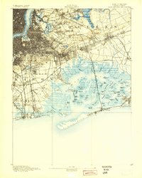
Brooklyn, New York: USGS topographic map, 1:62,500 (1889–1900)
1889–1900 · 17 editions

Brooklyn Sketch 1879
c. 1879 · Library of Congress

Bird's-eye-view of the borough of Brooklyn showing parks, cemeteries, principal buildings, suburbs.
1897 · Library of Congress

The city of Brooklyn.
1879 · Library of Congress

Map of the city of Brooklyn.
1864 · Library of Congress

Map of Kings and part of Queens counties, Long Island N.Y.
1852 · Library of Congress

Map of the city of Brooklyn.
1865 · Library of Congress

Map of Kings County N.Y.
1868 · Library of Congress
Views of the city
Search “bird's-eye view of New York City” for more, or ask Claude for it

The city of New York.
1884 · Library of Congress

The city of New York.
1870 · Library of Congress

The city of New York.
1892 · Library of Congress

The city of New York.
1886 · Library of Congress

The city of New York.
1883 · Library of Congress

View of the city of New York and vicinity
1907 · Library of Congress

The city of New York.
1876 · Library of Congress

The city of New York.
1889 · Library of Congress
Need photographs too? See Old New York photos on Find Any Photo, our search of public-domain archive photographs.
Need maps for a video, lesson or book?
Add Find Any Map to Claude and ask for the maps you need, part by part. Claude searches this index, shows you the matches with their licences and writes the credit lines.
Add to Claude for free