Old maps of Japan
Maps of Japan: Japanese maps of the whole country from the Edo period, plans of the cities of Edo (Tokyo), Kyoto and Osaka, and maps of Japan made by European mapmakers from the 1500s on.
Why they are free to use: Most were published more than a century ago, so their copyright has expired. Each map's page shows its own licence basis and a credit line.
Maps of Japan
Search “old map of Japan, the whole country” for more, or ask Claude for it

Dai Nihon enkai yochi zenzu
1800 · 2 sheets

Japan - Nipon, Kiusiu and Sikok, and a part of the coast of Korea
1855 · Library of Congress

(Nihon-zu sara).
1830 · Library of Congress

Map of eastern China, Japan, and Korea.
1880 · Library of Congress

Chōsen hachidō no zu - 5-mai no uchi, betsuni setsuari.
1785 · Library of Congress

(Nihon yochi rotei zenzu.
1779 · Library of Congress

Japanese map of the world, 1792.
1792 · Wikimedia Commons

Relief shown by contours and hachures. Includes map of "Japan or Nippon." Appears in: Rand, McNally & Company's Indexed Atlas of the World. In upper left corner: 198. In upper right corner: 199.
1883 · Library of Congress
Edo and Tokyo
Search “old map of the city of Edo Tokyo” for more, or ask Claude for it

Reproduction of Chōroku-Period Map of Edo, with Later Additions
1804 · Wikimedia Commons

(Chōroku Edo zu utsushi.
1804 · Library of Congress

Sunshū fuchū oshiro no zu.
1607 · Library of Congress

Dai Nihon enkai yochi zenzu
1800 · Library of Congress

Pekin kinbō zu.
1894 · Library of Congress

Shinkoku fukui butoku anmin, Okatame taihei kagami - Izu, Sagami, Musashi, Awa, Kazusa, Shimōsa.
1852 · Library of Congress
European maps of Japan
Search “European map of Japan 1600s 1700s” for more, or ask Claude for it

People of Many Nations
1800–1850 · Wikimedia Commons

1710 Japanese Buddhist map of the World - Nansenbushu Bankoku Shoka No Zu - Outline Map of All Countries of the Universe
1710 · Wikimedia Commons

Nansenbushu Bankoku Shoka No Zu (Outline Map of All Countries of the Universe)
1710 · Wikimedia Commons
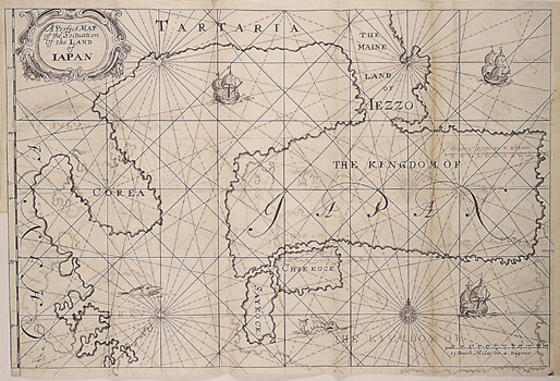
A Perfect Map of the Situation of the Land of Iapan
1663 · Wikimedia Commons

Noordtoost cust van Asia, van Japan tot Nova Zemla.
1672 · New York Public Library

Two screens World and Japan
c. 1600 · Wikimedia Commons

World map from Japan, Bankoku sozu, 1671
1671 · Wikimedia Commons

Nansenbushu Bankoku Shoka No Zu (Outline Map of All Countries of the Universe)
1710 · Wikimedia Commons
Need maps for a video, lesson or book?
Add Find Any Map to Claude and ask for the maps you need, part by part. Claude searches this index, shows you the matches with their licences and writes the credit lines.
Add to Claude for free