

MPK1-426 Sykes Picot Agreement Map signed 8 May 1916
Map showing Eastern Turkey in Asia, Syria and Western Persia, and areas of control and influence agreed upon between the British and the French. Royal Geographical Society, 1910-15. Signed by Mark Sykes and François Georges-Picot, 8 May 1916.
- Date
- 1916
- Mapmaker / publisher
- Royal Geographical Society (Map), Mark Sykes & François Georges-Picot (Annotations)
- Place
- the Sykes-Picot Agreement
- Archive
- Wikimedia Commons
- Type
- map
- Original size
- 3,322 × 3,225 pixels
Public domainsafest
Reason: its US copyright has expired (published before 1931).
Read from: Commons licence category: PD US expired; no CC BY, CC BY-SA, GFDL or deletion tag on the file page.
Credit line
"MPK1-426 Sykes Picot Agreement Map signed 8 May 1916" (1916). Royal Geographical Society (Map), Mark Sykes & François Georges-Picot (Annotations), via Wikimedia Commons. Public domain. https://commons.wikimedia.org/wiki/File:MPK1-426_Sykes_Picot_Agreement_Map_signed_8_May_1916.jpgNeed maps for a whole project? Add Find Any Map to Claude and ask for this one by its id: 15220.
More like this

تقسيم الشام والعراق - سايكس بيكو
1946 · Wikimedia Commons

Map of eastern Turkey in Asia, Syria and western Persia (ethnographical).
1910 · Library of Congress

Lawrence of Arabia's map, presented to the Eastern Committee of the War Cabinet in November 1918
1918 · Wikimedia Commons
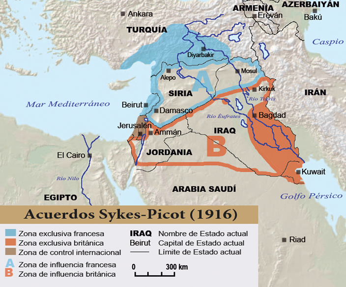
Sykes-picot
Wikimedia Commons

Middle East 1914-1919
1919 · Wikimedia Commons

Ray Stannard Baker's diagram of the six secret agreements which were used in the negotiations to partition the Ottoman Empire
1923 · Wikimedia Commons

Map of eastern Turkey in Asia, Syria and western Persia the period of the Babylonian and Assyrian empires. 1 colour topographic basemap with red overprint showing map of Babylonian and Assyrian empires, with positions of principal Assyrian rock-cut inscriptions. Elevation shown by hachures and spot
1915 · Wikimedia Commons

Northern Syria and Lebanon in Maunsell's map, Pre-World War I British Ethnographical Map of eastern Turkey in Asia, Syria and western Persia 04
1910 · Library of Congress