

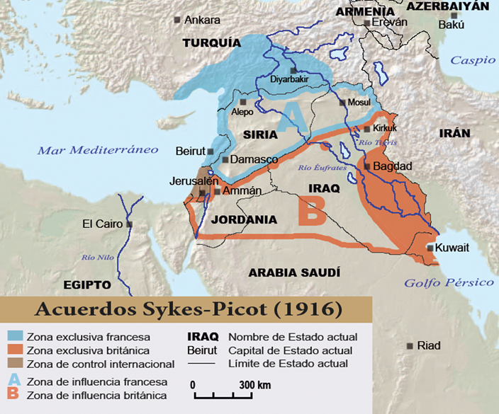
تقسيم الشام والعراق - سايكس بيكو
The Dividing of Iraq and the Levant according to Sykes Picot Agreement between Britain and France, after the fall of the Ottoman Empire.
- Date
- 1946
- Place
- the Sykes-Picot Agreement
- Archive
- Wikimedia Commons
- Type
- map
- Original size
- 2,279 × 2,020 pixels
Public domain
Reason: public domain: Lebanon.
This status rests on the map's publication history, as researched by Wikimedia Commons. Check it before commercial use.
Read from: Commons licence category: PD-Lebanon; no CC BY, CC BY-SA, GFDL or deletion tag on the file page; permission field: More than 50 years have passed since the creation of this map, and according to the Lebanese Law its now in the public D.
Credit line
"تقسيم الشام والعراق - سايكس بيكو" (1946). Wikimedia Commons. Public domain. https://commons.wikimedia.org/wiki/File:%D8%AA%D9%82%D8%B3%D9%8A%D9%85_%D8%A7%D9%84%D8%B4%D8%A7%D9%85_%D9%88%D8%A7%D9%84%D8%B9%D8%B1%D8%A7%D9%82_-_%D8%B3%D8%A7%D9%8A%D9%83%D8%B3_%D8%A8%D9%8A%D9%83%D9%88.jpgNeed maps for a whole project? Add Find Any Map to Claude and ask for this one by its id: 15263.
More like this
Sykes-picot
Wikimedia Commons

MPK1-426 Sykes Picot Agreement Map signed 8 May 1916
1916 · Wikimedia Commons

Ray Stannard Baker's diagram of the six secret agreements which were used in the negotiations to partition the Ottoman Empire
1923 · Wikimedia Commons

Ottoman Empire in Asia 1914
1924 · Wikimedia Commons

Lawrence of Arabia's map, presented to the Eastern Committee of the War Cabinet in November 1918
1918 · Wikimedia Commons

Palestine claimed by WZO 1919-ar
April 28, 2020 · Wikimedia Commons

Sykes-Picot Division. Note: It is known that Saida (present Sidon in Lebanon) was wrongly marked on the location of Sur (present Tyre, just north of the brown area of Palestine). The correct location
1919 · Wikimedia Commons

Syria and Palestine
1925 · Wikimedia Commons