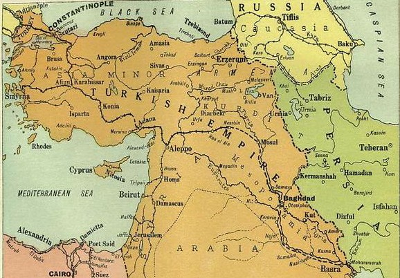

Middle East 1914-1919
Map Illustrate the Mesopotamian Expedition, 1919. Showing the Middle Eastern theatre of World War I, including the Turkish or Ottoman Empire, and parts of Russia, Persia and Egypt. From "The History of the Great European War: its causes and effects", Vol. V, by W. Stanley Macbean Knight. Caxton Pulishing Company, Limited, London, 1919. Artist George Philip & Son Ltd.
- Date
- 1919
- Mapmaker / publisher
- W. Stanley Macbean Knight, Artist George Philip & Son Ltd
- Place
- the Near East
- Archive
- Wikimedia Commons
- Type
- map
- Original size
- 578 × 402 pixels
Public domain
Reason: its maker died long enough ago that the copyright has expired.
This status rests on the map's publication history, as researched by Wikimedia Commons. Check it before commercial use.
Read from: Commons licence category: PD Old; no CC BY, CC BY-SA, GFDL or deletion tag on the file page.
Credit line
"Middle East 1914-1919" (1919). W. Stanley Macbean Knight, Artist George Philip & Son Ltd, via Wikimedia Commons. Public domain. https://commons.wikimedia.org/wiki/File:Middle_East_1914-1919.jpgNeed maps for a whole project? Add Find Any Map to Claude and ask for this one by its id: 239268.
More like this

War Map of the middle east: illustrating the campaigns in Persia, Mesopotamia and the Caucasus
1910 · Plate 1 of 2

Philips' strategical map of Mesopotamia & Asia Minor
Wikimedia Commons

Mideast1920
1920 · Wikimedia Commons

Bartholomew's map of Asia Minor, Egypt, Mesopotamia and Persia
Wikimedia Commons

Ottoman Middle East in 1900, Edward Stanford
1900 · Library of Congress

The Euphrates Valley - Syria, Kurdistan, etc.
1900 · Library of Congress

1915 bird's eye view map of the Middle Eastern theatre of World War I
1915 · Wikimedia Commons

Middle East.
1918 · Library of Congress