

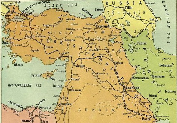
Middle East.
Shows railroads, roads and geographic divisions as they were before the end of World War I. Map centered on Iran.
- Date
- 1918
- Mapmaker / publisher
- American Geographical Society Of New York
- Place
- the Middle East
- Archive
- Library of Congress (via Wikimedia Commons)
- Type
- map
- Original size
- 10,208 × 6,401 pixels
Public domainsafest
Reason: its maker died more than 80 years ago.
Read from: Commons licence category: PD-old-80-expired; no CC BY, CC BY-SA, GFDL or deletion tag on the file page.
Credit line
"Middle East." (1918). American Geographical Society Of New York. Library of Congress, Geography and Map Division, via Wikimedia Commons. Public domain. https://commons.wikimedia.org/wiki/File:Middle_East._LOC_2013586103.jpgNeed maps for a whole project? Add Find Any Map to Claude and ask for this one by its id: 18137.
More like this

War Map of the middle east: illustrating the campaigns in Persia, Mesopotamia and the Caucasus
1910 · Wikimedia Commons

Bartholomew's map of Asia Minor, Egypt, Mesopotamia and Persia
Wikimedia Commons

Map of eastern Turkey in Asia, Syria and western Persia (ethnographical).
1910 · Library of Congress

text removed from:File:"Where The Victims Are.Save The Survivors- 3,950,000 starving people.Campaign for $30,000,000.", ca. 1917 - ca. 1919 - NARA - 512642.jpg
c. 1918 · Wikimedia Commons

Newsmap - The Middle East
April 1, 1946 · Wikimedia Commons
Middle East 1914-1919
1919 · Wikimedia Commons

Middle East in 1942, during World War II
1942 · Wikimedia Commons

Mideast1920
1920 · Wikimedia Commons