

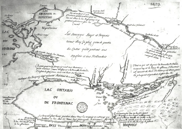
Map of Huron Country, 1631–51
This important manuscript map on vellum depicts part of present-day Ontario, Canada, extending from Georgian Bay in the north (Partie du Grand Lac des Hurons) to Lake Ontario in the south, and from Lake Huron in the west to Lake Simcoe in the east (Lac Oventarenk). The map originally was dated 1631, but the date later was changed to 1651. Canadian scholar Conrad E. Heidenreich concluded that the main part of the map probably was drawn between 1639 and 1648, with slight revisions made after 1650, which most likely explains the change from 1631 to 1651. Heidenreich also surmised that the map, which is unsigned, was drawn by Saint Jean de Brébeuf (1593–1649). The map evidently was made to illustrate the location of Indian tribes and Jesuit missions, particularly in the area between Lake Simcoe and Georgian Bay. Brébeuf was born in Normandy, France, and joined the Jesuit order in 1617. In 1626 he established the first mission among the Huron Indians. He was captured by the Iroquois, enemies of the Hurons, then tortured and burned to death on March 16, 1649. He was canonized in 1930. Georgian Bay (Ontario: Bay); Great Lakes Region (North America); Huron, Lake (Michigan and Ontario); Je
- Date
- 1639–1651
- Mapmaker / publisher
- Brébeuf, Jean de, saint, 1593-1649
- Place
- Lake Simcoe
- Archive
- Wikimedia Commons
- Type
- map
- Original size
- 1,236 × 1,024 pixels
Public domainsafest
Reason: its maker died more than 100 years ago, and a faithful scan of a flat work adds no new copyright.
Read from: Commons licence category: PD-Art (PD-old-100); no CC BY, CC BY-SA, GFDL or deletion tag on the file page.
Credit line
"Map of Huron Country, 1631–51" (1639–1651). Brébeuf, Jean de, saint, 1593-1649, via Wikimedia Commons. Public domain. https://commons.wikimedia.org/wiki/File:Map_of_Huron_Country,_1631%E2%80%9351_WDL9557.pngNeed maps for a whole project? Add Find Any Map to Claude and ask for this one by its id: 295456.
More like this

Description du pais des Hurons.
1651 · Library of Congress

Upper Canada and the Iroquois Confederacy
1860 · Wikimedia Commons

Darlinton map of lake huron 1680
1680 · Wikimedia Commons

Carte de Guillaume Delisle tirée des relations des Hurons de 1639, 1640 et 1641
1703 · Wikimedia Commons

Sketch Map of Upper Canada. routes Lt Gov Simcoe took.1793-5
1793–1795 · Wikimedia Commons

Novae Franciae accurata delineatio 1657.
1657 · Library of Congress

Sketch map of Upper Canada showing the routes Lt. Gov. Simcoe took on journeys between March 1793 and September 1795
1795 · Wikimedia Commons
Early map of Lake Ontario
Wikimedia Commons