

Descriptio Prime Tabulae Europae
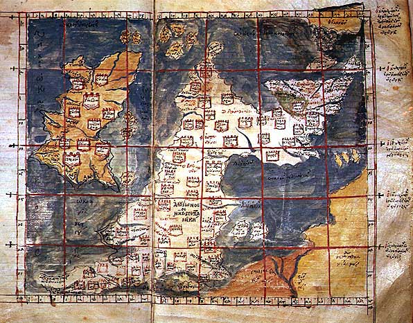
The 1st Map of Europe: A Latin map of the British Isles (Insulae Britannicae): Ireland (Hybernia) and Britain (Alvion), based on Ptolemy's Geography. Note the positioning of Scotland at a right angle to the rest of Britain.
- Date
- 1450–1475
- Mapmaker / publisher
- Credited to Francesco di Antonio del Chierico in Florence; text Emanuel Chrysoloras and Jacobus Angelus's translation of Ptolemy's Geography
- Place
- the British Isles in the 1st century
- Archive
- Wikimedia Commons
- Type
- map
- Original size
- 1,500 × 960 pixels
Public domainsafest
Reason: its maker died more than 100 years ago, and a faithful scan of a flat work adds no new copyright.
Read from: Commons licence category: PD-Art (PD-old-100); no CC BY, CC BY-SA, GFDL or deletion tag on the file page.
Credit line
"Descriptio Prime Tabulae Europae" (1450–1475). Credited to Francesco di Antonio del Chierico in Florence; text Emanuel Chrysoloras and Jacobus Angelus's translation of Ptolemy's Geography, via Wikimedia Commons. Public domain. https://commons.wikimedia.org/wiki/File:Descriptio_Prime_Tabulae_Europae.jpgNeed maps for a whole project? Add Find Any Map to Claude and ask for this one by its id: 245871.
More like this

Europe Tabula Prima
1426 · Wikimedia Commons
Ptolemaic Britain
Wikimedia Commons

Iouernia kai Alouionos Nesoi
Wikimedia Commons

Iouernia kai Alouionos Nesoi B
Wikimedia Commons

Prima Europe Tabula
1478 · Wikimedia Commons

Карта Птолемея
Wikimedia Commons

Prima Europe tabula
1486 · Wikimedia Commons

Tabula Europae I
1552 · Wikimedia Commons