

Laurila–Kelloselkä-Kantalahti railway
Finnish railway lines also extend to Kolari and Taivalkoski
- Date
- December 2, 2009
- Mapmaker / publisher
- Central Intelligence Agency * derivative work: User:Petri Krohn
- Place
- Lapland, Finland
- Archive
- Wikimedia Commons
- Type
- map
- Original size
- 657 × 411 pixels
Public domain
Reason: a US government work (Central Intelligence Agency).
This status rests on the map's publication history, as researched by Wikimedia Commons. Check it before commercial use.
Read from: Commons licence category: PD CIA; no CC BY, CC BY-SA, GFDL or deletion tag on the file page.
Credit line
"Laurila–Kelloselkä-Kantalahti railway" (December 2, 2009). Central Intelligence Agency * derivative work: User:Petri Krohn, via Wikimedia Commons. Public domain. https://commons.wikimedia.org/wiki/File:Laurila%E2%80%93Kelloselk%C3%A4-Kantalahti_railway.jpgNeed maps for a whole project? Add Find Any Map to Claude and ask for this one by its id: 23627.
More like this

Finland-Russia border
February 1, 1967 · Wikimedia Commons

Karelo-Finnish SSR, 1941-1944
December 7, 2017 · Wikimedia Commons

Soviet-finnish negotiations 1939 borderline finnish
September 10, 2009 · Wikimedia Commons
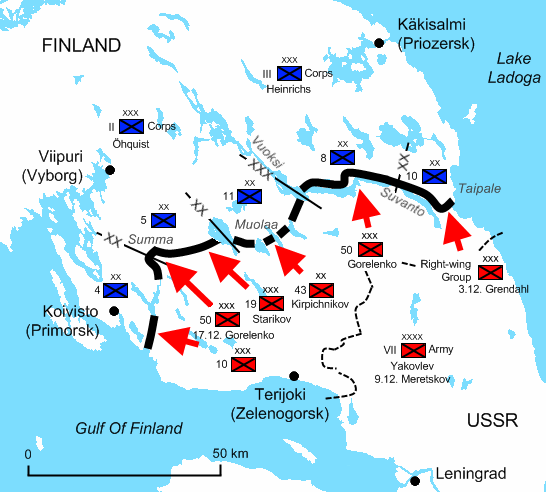
The Winter War situation in December 1939. The Soviets have reached the Finnish main defence line, the:en:Mannerheim Line, on the Karelian Isthmus. -XX- Finnish Divisional Boundary -XXX- Finnish Corps
July 5, 2009 · Wikimedia Commons
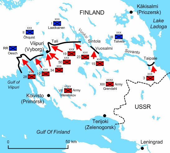
Karelian Isthmus 13 March 1940
September 13, 2009 · Wikimedia Commons

Operation Barbarossa corrected border
October 15, 2006 · Wikimedia Commons

Winter War Soviet attacks December 1939 russian
September 20, 2009 · Wikimedia Commons

The German withdrawal from Finland
1968 · Wikimedia Commons