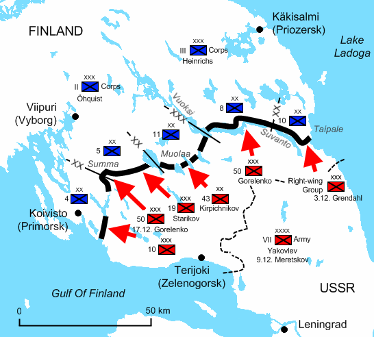

The Winter War situation in December 1939. The Soviets have reached the Finnish main defence line, the:en:Mannerheim Line, on the Karelian Isthmus. -XX- Finnish Divisional Boundary -XXX- Finnish Corps
- Date
- July 5, 2009
- Mapmaker / publisher
- Peltimikko
- Place
- Finland in Winter War
- Archive
- Wikimedia Commons
- Type
- map
- Original size
- 546 × 492 pixels
Public domain
Reason: public domain: self.
This status rests on the map's publication history, as researched by Wikimedia Commons. Check it before commercial use.
Read from: Commons licence category: PD-self; no CC BY, CC BY-SA, GFDL or deletion tag on the file page.
Credit line
"The Winter War situation in December 1939. The Soviets have reached the Finnish main defence line, the:en:Mannerheim Line, on the Karelian Isthmus. -XX- Finnish Divisional Boundary -XXX- Finnish Corps" (July 5, 2009). Peltimikko, via Wikimedia Commons. Public domain. https://commons.wikimedia.org/wiki/File:Winterwar-december1939-karelianisthmus.pngNeed maps for a whole project? Add Find Any Map to Claude and ask for this one by its id: 23505.
More like this

Winterwar-december1939-karelianisthmus finnish
July 17, 2009 · Wikimedia Commons
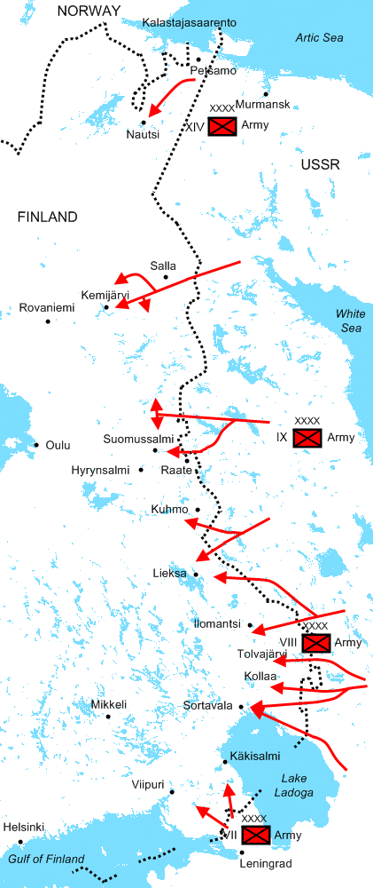
The Soviet major offensives of 30 November - 22 December 1939 in the Winter War.
July 6, 2009 · Wikimedia Commons

Winterwar-december1939-soviet-attacks finnish
July 17, 2009 · Wikimedia Commons

Battles in the Ladoga Karelia, north of Lake Ladoga. The attack of the Eighth Army of Red Army has been stopped at the Finnish defense on 12 December 1939.
July 12, 2009 · Wikimedia Commons

Ladogakarelia-winterwar-dec-1939 finnish
July 17, 2009 · Wikimedia Commons

Karelian Ishtmus December 1939 russian
September 20, 2009 · Wikimedia Commons

Winterwar-december1939-karelianisthmus-ar
March 7, 2022 · Wikimedia Commons

Winter War Soviet attacks December 1939 russian
September 20, 2009 · Wikimedia Commons