

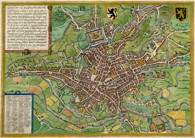
Ghent, Belgium, Braun & Hogenberg, 1572 B&W
Name of map: Gandavum Cartographer: Braun & Hogenberg Stock number: 3126 Map number:(Koeman Atlantes Neerlandici II): p. 15, map 15. State number of plate: 1 Copy from edition: 1572 Latin; Page signature: 14 Area displayed: City of Gent (Flanders); Plate size: 338 x 487 mm Paper size: 404 x 557 mm; Margins, left: 30 mm, right: 36 mm; upper: 36 mm, lower: 28 mm; Paper thickness and quality: thin but strong; Paper color: off white; Age of map color: uncoloured; Imperfections margins: tiny tears in bottom margin; plate: none; verso: none; Overall quality:perfect/EXCELLENT/very good/good/fair/mediocre/poor
- Date
- 1572
- Mapmaker / publisher
- Braun_&_Hogenberg
- Place
- Ghent by Braun & Hogenberg
- Archive
- Wikimedia Commons
- Type
- map
- Original size
- 1,846 × 1,356 pixels
Public domainsafest
Reason: its maker died more than 100 years ago, and a faithful scan of a flat work adds no new copyright.
Read from: Commons licence category: PD-Art (PD-old-100); no CC BY, CC BY-SA, GFDL or deletion tag on the file page.
Credit line
"Ghent, Belgium, Braun & Hogenberg, 1572 B&W" (1572). Braun_&_Hogenberg, via Wikimedia Commons. Public domain. https://commons.wikimedia.org/wiki/File:Ghent,_Belgium,_Braun_%26_Hogenberg,_1572_B%26W.jpgNeed maps for a whole project? Add Find Any Map to Claude and ask for this one by its id: 140412.
More like this
Ghent, Belgium; Braun & Hogenberg 1576
1576 · Wikimedia Commons

Ghent, map 1572
1572 · Wikimedia Commons

Gandauum Amplissima Flandriae Urbs,. Author: G.Braun & F.Hogenberg PlaceAndYear: Cologne 1572 Description: Flemish Ghent is shown here from the northwest and from a great height - the towns major buildings and the mills are minutely placed between the rivers. A cartouche in Latin at top left desc
1572 · Wikimedia Commons

Map of Ghent by Hadrianus Barlandus,1574
1574 · Wikimedia Commons

Gandavum, amplissima Flandriae urbs, a Julio Caesare condita. / Hadria. Barl.
1574 · Wikimedia Commons

Gandavum, amplissima Flandriae urbs.
1645 · Ghent, plate 1 of 2

Ghent, Belgium, Braun & Hogenberg, 1572-1624
1572–1624 · Wikimedia Commons

Gandaaum, Braun and Hogenberg
1618 · Wikimedia Commons