

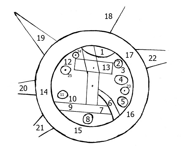
Geography 004 - Babylonian Map of the World - Interpretation
Year Created: c.700 to 500 BCE Country of Origin: Sippar, southern Iraq Creator: Unknown Babylonian cartographer Materials Used: Etched clay tablet Area Depicted: Known world at the time to the Babylonians; centered on the Euphrates River web.archive.org/web/20210513215609/http:/www.henry-davis.
- Mapmaker / publisher
- BioKnowlogy
- Archive
- Wikimedia Commons
- Type
- map
- Original size
- 1,092 × 966 pixels
Public domain
Reason: public domain: author-FlickrPDM.
This status rests on the map's publication history, as researched by Wikimedia Commons. Check it before commercial use.
Read from: Commons licence category: PD-author-FlickrPDM; no CC BY, CC BY-SA, GFDL or deletion tag on the file page.
Credit line
"Geography 004 - Babylonian Map of the World - Interpretation". BioKnowlogy, via Wikimedia Commons. Public domain. https://commons.wikimedia.org/wiki/File:Geography_004_-_Babylonian_Map_of_the_World_-_Interpretation.jpgNeed maps for a whole project? Add Find Any Map to Claude and ask for this one by its id: 144659.
More like this

Babylonian Map of the World, 700-500 BC
1500 · Wikimedia Commons

Meissner Babylonien und Assyrien clay map 1925
1925 · Wikimedia Commons
skeleton map of Babylonian World Map
2009 · Wikimedia Commons

Geography 015 - Ancient Greece Map of the World - c. 5th century BCE
Wikimedia Commons

Habitabilis Nostre Tabula IV
1478 · Wikimedia Commons

Habitabilis Nostre Tabula
1478 · Wikimedia Commons

Habitabilis Nostre Tabula II
1478 · Wikimedia Commons

Habitabilis Nostre Tabula III
1478 · Wikimedia Commons