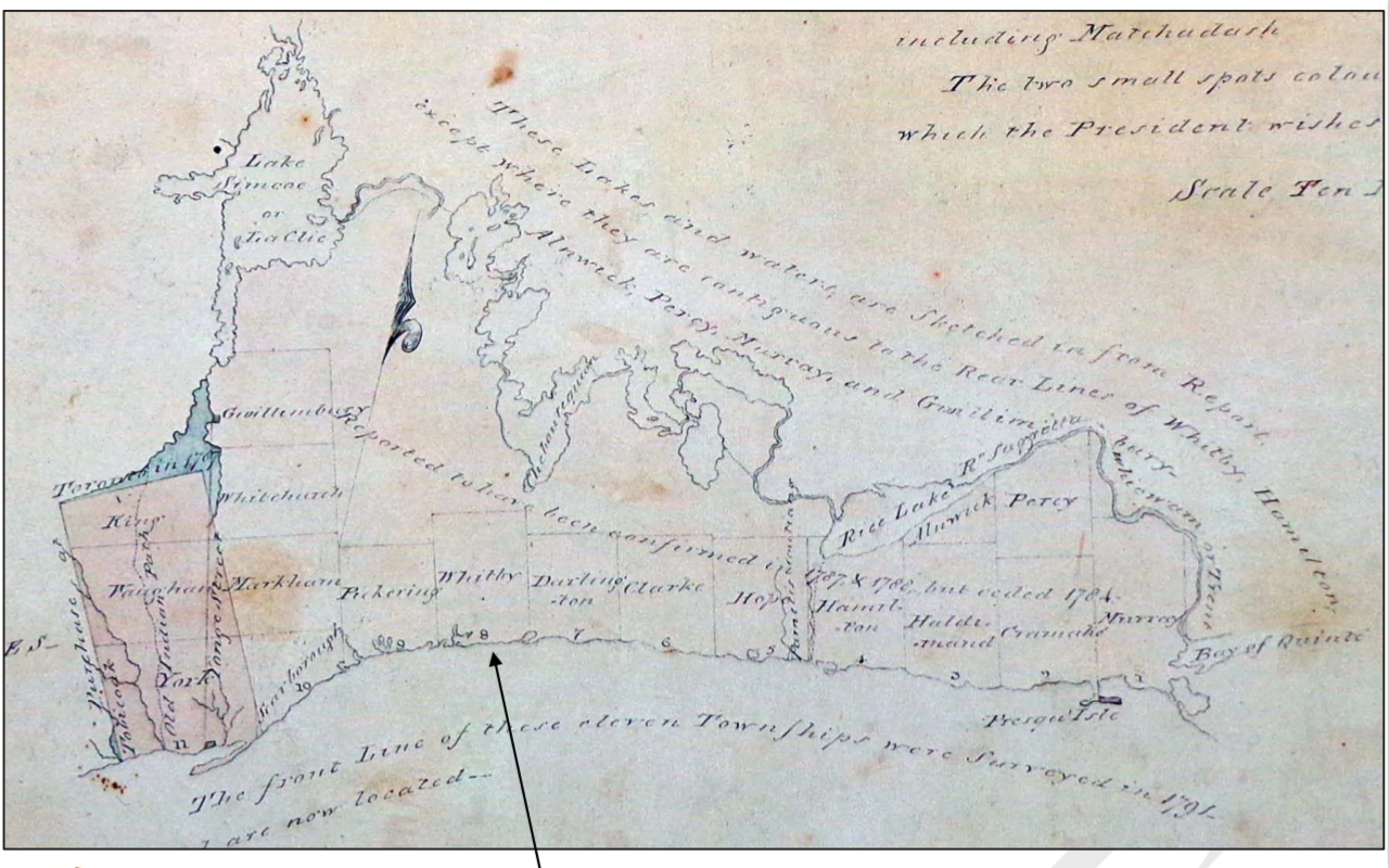

Genticore plate, Upper Canada
Genticore plate. From west to east, and north to south, are depicted thw townships of York, Vaughan, King, Scarborough, Markham, Whitchurch, Gwillimbury, Pickering, Whitby, Darlington, Clarke, Hope, Hamilton, Haldimand, Cramahe, and Murray. Demarcated at left is the 'Purchase of Toronto in 1787'. Also shown are Bay of Quinte and Lake Simcoe, with its older name Lac Clie.
- Date
- 1790–1799
- Place
- Ontario
- Archive
- Wikimedia Commons
- Type
- map
- Original size
- 1,280 × 800 pixels
Public domain
Reason: public domain: Canada.
This status rests on the map's publication history, as researched by Wikimedia Commons. Check it before commercial use.
Read from: Commons licence category: PD Canada; no CC BY, CC BY-SA, GFDL or deletion tag on the file page.
Credit line
"Genticore plate, Upper Canada" (1790–1799). Wikimedia Commons. Public domain. https://commons.wikimedia.org/wiki/File:Genticore_plate,_Upper_Canada.pngNeed maps for a whole project? Add Find Any Map to Claude and ask for this one by its id: 295467.
More like this

Sketch Map of Upper Canada. routes Lt Gov Simcoe took.1793-5
1793–1795 · Wikimedia Commons

Upper Canada 1795
1800 · Wikimedia Commons

Sketch map of Upper Canada showing the routes Lt. Gov. Simcoe took on journeys between March 1793 and September 1795
1795 · Wikimedia Commons

Detail, showing region surrounding York, from William Chewitt's 1821 map of Upper Canada
1821 · Wikimedia Commons

Uppercanada1800map
1800 · Wikimedia Commons

Upper Canada and the Iroquois Confederacy
1860 · Wikimedia Commons

A map of Upper Canada, 1826
1826 · Wikimedia Commons

Surveryor's map of Gananoque 1787
1787 · Wikimedia Commons