

EB 1911 Map Fig 10
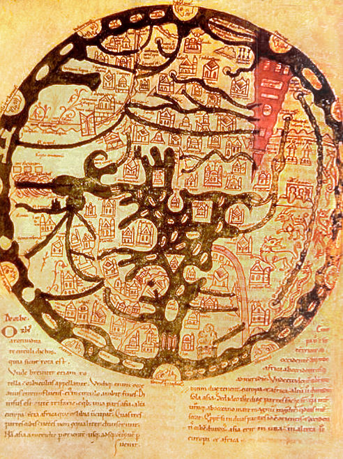
Caption: " —Map illustrating w:Sallust's Bellum jugurthinum (11th century, Leipzig)." A somewhat detailed Latin T&O map with east at the top, but only identified by labeling the bottom of the map "West" (Occidens). Asia is decorated with the cities of Babylon (Babilonia), Troy (Troia), and unlabelled Jerusalem and the mountains of Lebanon (Libanus). It also has the cities of Sestos, Sidon (Sydon), and Tyre (Tyrus) labelled. Europe (Europa) is decorated with the city of Rome (Roma) and the Alps (Alpes) and Pyrenees (Pirrens). The city of Constantinople (Const.) and lands of Greece (Grecia), Spain (Hispania), and France (Francia). Africa is decorated with the 2 unlabelled cities as well as those of Carthage (Kartago), Leptis Magna (Leptis), and Cyrene (Cirene). The lands of Syrtis, Locapet, Ethiopia (Ethiopea), Geruli, the Moors (Mauri), Libya (Libies), Numidia, and very misplaced Armenia. The Temple of Ammon is separately listed and Egypt made an island between the Nile (Nilus) and the Catabathmon Mountains, misunderstood as a river or sea.
- Date
- c. 1911
- Mapmaker / publisher
- Presumably Emery Walker
- Archive
- Wikimedia Commons
- Type
- map
- Original size
- 1,368 × 1,396 pixels
Public domain
Reason: a US government work.
This status rests on the map's publication history, as researched by Wikimedia Commons. Check it before commercial use.
Read from: Commons licence category: PD US; no CC BY, CC BY-SA, GFDL or deletion tag on the file page; permission field: PD-US; PD-Britannica; PD-Art.
Credit line
"EB 1911 Map Fig 10" (c. 1911). Presumably Emery Walker, via Wikimedia Commons. Public domain. https://commons.wikimedia.org/wiki/File:EB_1911_Map_Fig_10.pngNeed maps for a whole project? Add Find Any Map to Claude and ask for this one by its id: 145873.
More like this

EB 1911 Map Fig 9
c. 1911 · Wikimedia Commons

EB 1911 Map Fig 7
c. 1911 · Wikimedia Commons

EB 1911 Map Fig 8
c. 1911 · Wikimedia Commons

1911 EB Map Fig 11
1300–1911 · Wikimedia Commons

EB 1911 Map Fig 5
c. 1911 · Wikimedia Commons

1420 Sallust de Geneve
1420 · Wikimedia Commons

Noachide map from the Abbey library of Saint Gall (oldest map naming Europe), Isidore-Codex 236
Wikimedia Commons
A map of the known world (mappa mundi) from an 11th century copy of the writings of Isidore of Seville (AD 560-636). East is placed at top, and the Red Sea is shown in red, as usual for such maps. Ima
Wikimedia Commons