

Dunstermap px20
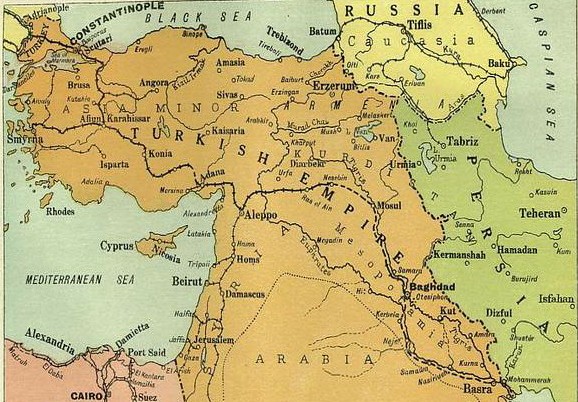
Map of the Ottoman Empire, Iran, Caucasia, Central Asia and Afghanistan
- Date
- 1919
- Mapmaker / publisher
- Staff writers
- Place
- Afghanistan
- Archive
- Wikimedia Commons
- Type
- map
- Original size
- 1,044 × 625 pixels
Public domain
Reason: a US government work.
This status rests on the map's publication history, as researched by Wikimedia Commons. Check it before commercial use.
Read from: Commons licence category: PD US; no CC BY, CC BY-SA, GFDL or deletion tag on the file page.
Credit line
"Dunstermap px20" (1919). Staff writers, via Wikimedia Commons. Public domain. https://commons.wikimedia.org/wiki/File:Dunstermap_px20.pngNeed maps for a whole project? Add Find Any Map to Claude and ask for this one by its id: 297733.
More like this

War Map of the middle east: illustrating the campaigns in Persia, Mesopotamia and the Caucasus
1910 · Plate 1 of 2

Stanford's Map of Western Asia
1885 · Central Asia

A map of the countries between Constantinople and Calcutta including Turkey in Asia, Persia, Afghanistan and Turkestan
1912 · Edward Stanford Ltd, Including Turkey in Asia, Persia, Afghanistan…

Middle East.
1918 · Library of Congress
Middle East 1914-1919
1919 · Wikimedia Commons

Map of Asian Turkey, Persia, Afghanistan, Balochistan, and the Khanate of Bukhara, with Some of the Neighboring Countries
1848 · Wikimedia Commons

A map of the countries between Constantinople and Calcutta - including Turkey in Asia, Persia, Afghanistan and Turkestan.
1912 · Library of Congress

Carte de la Turquie D'Asie, de la Perse- de l'Afghanistan, du Belouchistan et de la grande Boukharie; avec une partie des Etats voisins
1848 · Library of Congress