

Byzantine Constantinople
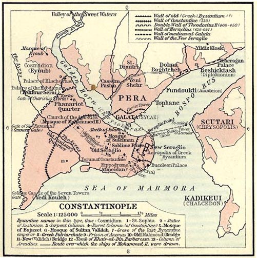
Detailed map of the City of Constantinople and its most important buildings in Byzantine times.
- Date
- 1899
- Mapmaker / publisher
- F.R. von Hubner
- Place
- Constantinople
- Archive
- Wikimedia Commons
- Type
- map
- Original size
- 1,500 × 1,113 pixels
Public domainsafest
Reason: public domain: scan (PD-old-assumed).
Read from: Commons licence category: PD-scan (PD-old-assumed); no CC BY, CC BY-SA, GFDL or deletion tag on the file page.
Credit line
"Byzantine Constantinople" (1899). F.R. von Hubner, via Wikimedia Commons. Public domain. https://commons.wikimedia.org/wiki/File:Byzantine_Constantinople.pngNeed maps for a whole project? Add Find Any Map to Claude and ask for this one by its id: 246193.
More like this

Plan of Constantinople
1854 · Wikimedia Commons

Sketch map of Constantinople.
1911 · Wikimedia Commons

The delineation of Constantinople, as it stood in the year 1422 before it fell under the dominion of the Turks From du F - Gilles Pierre - 1729
1422 · Wikimedia Commons

Byzantium, nunc Constantinopolis
1635 · Constantinople, plate 2 of 3

Byzantium Nunc Constantinopolis
c. 1660 · Wikimedia Commons
(1911) Shepherd, William R. The Ottoman Empire, 1451-1481 and Constantinople., p. 93
1451 · Wikimedia Commons

Byzantium, nunc Constantinopolis
1645 · Constantinople, plate 1 of 2

1572 bird's eye view map of Constantinople - Byzantium Nunc Constantinopolis
1572 · Wikimedia Commons