

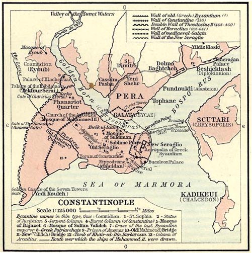
Sketch map of Constantinople.
- Date
- 1911
- Mapmaker / publisher
- Professor A. van Millingen, engraved by Emery Walker
- Place
- Constantinople
- Archive
- Wikimedia Commons
- Type
- map
- Original size
- 2,167 × 1,846 pixels
Public domain
Reason: a US government work.
This status rests on the map's publication history, as researched by Wikimedia Commons. Check it before commercial use.
Read from: Commons licence category: PD US; no CC BY, CC BY-SA, GFDL or deletion tag on the file page.
Credit line
"Sketch map of Constantinople." (1911). Professor A. van Millingen, engraved by Emery Walker, via Wikimedia Commons. Public domain. https://commons.wikimedia.org/wiki/File:EB1911-Constantinople.pngNeed maps for a whole project? Add Find Any Map to Claude and ask for this one by its id: 246199.
More like this

Карта к статье «Константинополь». Военная энциклопедия Сытина (Санкт-Петербург, 1911-1915)
1914 · Wikimedia Commons

Plan of Constantinople
1854 · Wikimedia Commons
(1911) Shepherd, William R. The Ottoman Empire, 1451-1481 and Constantinople., p. 93
1451 · Wikimedia Commons

The delineation of Constantinople, as it stood in the year 1422 before it fell under the dominion of the Turks From du F - Gilles Pierre - 1729
1422 · Wikimedia Commons

LA2-NSRW Constantinople
1914 · Wikimedia Commons

Constantinople in the 15th century (ver. 1)
Wikimedia Commons

Detail map of Constantinople. 1550
1550 · Library of Congress

Plan d'ensemble de la ville de Constantinople. Publisher: Societe anonyme ottomane d'etudes et d'enterprises urbaines PubInfo: 1922 Description: This map was scanned with a Chroma Tx 40 Plus Wide Format color scanner and WIDEimage 2.8 software at 400 DPI in 24-bit color. The image was then reduced t
1922 · Wikimedia Commons