

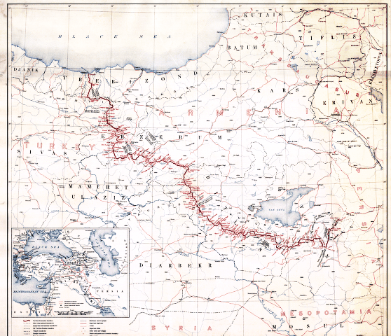
Boundary between Turkey and Armenia - as determined by Woodrow Wilson, president of the United States of America
Scale 1:1,000,000. Relief shown by spot heights. From the President Woodrow Wilson papers. Includes location map. Vault AACR2
- Date
- 1920
- Mapmaker / publisher
- Martin, Lawrence; Wilson, Woodrow; Geological Survey (U.S.). Topographic Branch; United States. Department Of State
- Place
- Armenia
- Scale
- 1:1,000,000
- Archive
- Library of Congress (via Wikimedia Commons)
- Type
- map
- Original size
- 8,953 × 8,820 pixels
Public domainsafest
Reason: its maker died more than 80 years ago.
Read from: Commons licence category: PD-old-80-expired; no CC BY, CC BY-SA, GFDL or deletion tag on the file page.
Credit line
"Boundary between Turkey and Armenia - as determined by Woodrow Wilson, president of the United States of America" (1920). Martin, Lawrence; Wilson, Woodrow; Geological Survey (U.S.). Topographic Branch; United States. Department Of State. Library of Congress, Geography and Map Division, via Wikimedia Commons. Public domain. https://commons.wikimedia.org/wiki/File:Boundary_between_Turkey_and_Armenia_-_as_determined_by_Woodrow_Wilson,_president_of_the_United_States_of_America_LOC_80695244.jpgNeed maps for a whole project? Add Find Any Map to Claude and ask for this one by its id: 9571.
More like this

Boundary between Turkey and Armenia as determined by Woodrow Wilson
August 26, 2012 · Wikimedia Commons

Map showing the boundaries of Armenia as awarded by President Wilson
1920 · Wikimedia Commons

Treaty of Sevres, President Wilson Armenian Boundary 02
July 28, 2012 · Wikimedia Commons

Boundary Between Turkey and Armenia: As Determined by Woodrow Wilson, President of the United States of America
1920 · Wikimedia Commons

Wilsonian Armenia National Geographic 1921
1921 · Wikimedia Commons
First republic of Armenia-west borders by Woodrow Wilson
Wikimedia Commons

Treaty of Sèvres &SovietRepublics of Transcaucasia
1921 · Wikimedia Commons

Treaty of Sèvres,1 Republic of Armenia,Greek Ionia
1920–1922 · Wikimedia Commons