

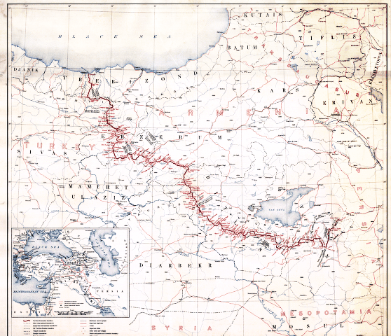
Boundary Between Turkey and Armenia: As Determined by Woodrow Wilson, President of the United States of America
The disintegration of the Ottoman and Russian empires at the end of World War I gave birth to a number of new states. In May 1918, Eastern Armenia, formerly part of the Russian Empire, declared itself an independent republic. In April 1920, the victorious Allied Powers, dismantling the Ottoman Empire, directed that Western Armenia be attached to the new republic and appointed U.S. President Woodrow Wilson to arbitrate the boundary between Turkey (successor to the Ottoman Empire) and Armenia. In November 1920, Wilson set a boundary based on a variety of geographic, demographic, ethnic, and historical factors. This map, compiled under the direction of the U.S. Army by the Topographic Branch of the U.S. Geological Survey, shows Wilson’s award. However, the Treaty of Sevres that provided for an independent Armenia and recognized Wilson’s arbitration was never ratified. Turkish nationalists under Mustafa Kemal overthrew the Turkish monarchy, established a republic, and invaded Armenia, eventually forcing it to relinquish much of the territory that Wilson’s arbitration had awarded to the new country. Russian Bolshevik forces also invaded Armenia and incorporated what was left of the Arme
- Date
- 1920
- Mapmaker / publisher
- Topographic Branch, U.S. Geological Survey
- Place
- Armenia
- Archive
- Wikimedia Commons
- Type
- map
- Original size
- 1,039 × 1,024 pixels
Public domainsafest
Reason: its maker died more than 70 years ago, and a faithful scan of a flat work adds no new copyright.
Read from: Commons licence category: PD-Art (PD-old-70); no CC BY, CC BY-SA, GFDL or deletion tag on the file page.
Credit line
"Boundary Between Turkey and Armenia: As Determined by Woodrow Wilson, President of the United States of America" (1920). Topographic Branch, U.S. Geological Survey, via Wikimedia Commons. Public domain. https://commons.wikimedia.org/wiki/File:Boundary_Between_Turkey_and_Armenia-_As_Determined_by_Woodrow_Wilson,_President_of_the_United_States_of_America_WDL47.pngNeed maps for a whole project? Add Find Any Map to Claude and ask for this one by its id: 22955.
More like this

Boundary between Turkey and Armenia - as determined by Woodrow Wilson, president of the United States of America
1920 · Library of Congress

Boundary between Turkey and Armenia as determined by Woodrow Wilson
August 26, 2012 · Wikimedia Commons

Map showing the boundaries of Armenia as awarded by President Wilson
1920 · Wikimedia Commons

Wilsonian Armenia National Geographic 1921
1921 · Wikimedia Commons

Armenia by the Sevres Treaty 1920
September 24, 2011 · Wikimedia Commons

Treaty of Sevres, President Wilson Armenian Boundary 02
July 28, 2012 · Wikimedia Commons
First republic of Armenia-west borders by Woodrow Wilson
Wikimedia Commons

Armenia in Paris Peace Conference 1919
1919 · Wikimedia Commons