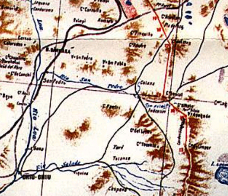

Silala en mapa 1904
Extract of the provisional map with the border demarcation between Chile and Bolivia according to the 1904 peace treaty. The extract focuses on the area of the current Silala dispute between both countries.
- Date
- 1904
- Mapmaker / publisher
- Lit. Suiza, Santiago
- Place
- Chile
- Archive
- Wikimedia Commons
- Type
- map
- Original size
- 470 × 404 pixels
Public domain
Reason: public domain: Chile.
This status rests on the map's publication history, as researched by Wikimedia Commons. Check it before commercial use.
Read from: Commons licence category: PD-Chile; no CC BY, CC BY-SA, GFDL or deletion tag on the file page.
Credit line
"Silala en mapa 1904" (1904). Lit. Suiza, Santiago, via Wikimedia Commons. Public domain. https://commons.wikimedia.org/wiki/File:Silala_en_mapa_1904.pngNeed maps for a whole project? Add Find Any Map to Claude and ask for this one by its id: 306290.
More like this

Plano provisorio frontera Chile-bolivia 1904
1904 · Wikimedia Commons

Lake Buenos Aires to Mount Fitzroy
1903 · Wikimedia Commons

Map "The southern regions of the Republics of Argentina and Chile" - 1904. This map, whose southern part is reproduced here, is included in Col. Sir Thomas Holdich's work "The Countries of the King's
1904 · Wikimedia Commons

Partial view of the Latzina map of 1882. The first official argentine map, produced, after the Boundary Treaty of 1881. It was ordered to be drawn up by the then Argentine Minister of the Interior, Be
1882 · Wikimedia Commons

Border Peru-Chile acc. 1929 Treaty
c. 1929 · Wikimedia Commons

Chile-Peru border region.
1974 · Library of Congress

Mapa argentino de 1912 mostrando los hitos del límite histórico acordados por los peritos de Argentina y Chile en el Campo de Hielo Patagónico Sur
1912 · Wikimedia Commons

Chile-Peru border region.
1974 · Library of Congress