

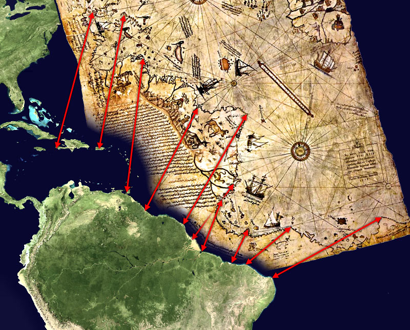
Piri Reis map interpretation
- Date
- January 10, 2006
- Mapmaker / publisher
- TMg Note: This interpretation is probably incorrect, the map only extends 5 degrees south of the equator, according to "Report No. 83-205 SPR The UFO Enigma, Marcia S. Smith, 20 June 1983, Congression
- Archive
- Wikimedia Commons
- Type
- map
- Original size
- 800 × 800 pixels
Public domain
Reason: public domain: self.
This status rests on the map's publication history, as researched by Wikimedia Commons. Check it before commercial use.
Read from: Commons licence category: PD-self; no CC BY, CC BY-SA, GFDL or deletion tag on the file page.
Credit line
"Piri Reis map interpretation" (January 10, 2006). TMg Note: This interpretation is probably incorrect, the map only extends 5 degrees south of the equator, according to "Report No. 83-205 SPR The UFO Enigma, Marcia S. Smith, 20 June 1983, Congression, via Wikimedia Commons. Public domain. https://commons.wikimedia.org/wiki/File:Piri_Reis_map_interpretation.jpgNeed maps for a whole project? Add Find Any Map to Claude and ask for this one by its id: 307384.
More like this
Piri Reis map interpretation RG
March 29, 2006 · Wikimedia Commons

1513 Piri Reis
c. 1513 · Wikimedia Commons

Piri reis world map 01
1513 · Wikimedia Commons

Piri reis harita
Wikimedia Commons

Reis map
Wikimedia Commons

Piri Reis map scale bar
1513 · Wikimedia Commons

1513 map by Piri Reis (detail fictional creature (human body without head on top, instead, the head is located on the chest)
c. 1513 · Wikimedia Commons

Piri Reis - Oval World Map - Google Art Project
Wikimedia Commons