

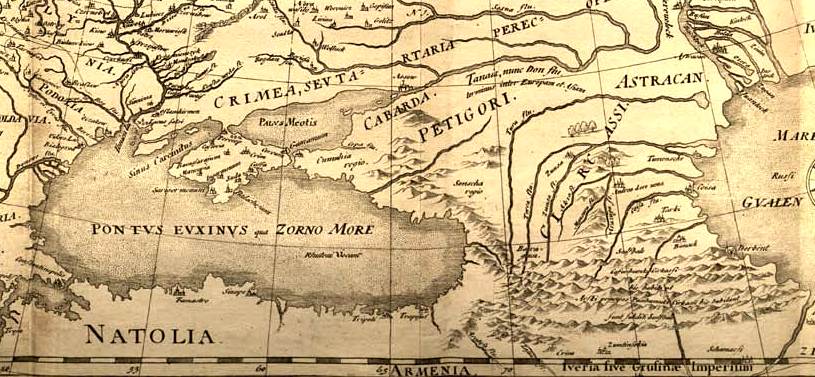
Ottoman Empire 1696 by Jaillot cropped and Caucasus
Map of Ottoman Empire and its divisions in 1600
- Date
- 1696
- Mapmaker / publisher
- Ottoman Empire 1696 by Jaillot.jpg: *derivative work: Geagea ( talk )
- Place
- Circassia
- Archive
- Wikimedia Commons
- Type
- map
- Original size
- 574 × 566 pixels
Public domainsafest
Reason: its maker died more than 100 years ago, and a faithful scan of a flat work adds no new copyright.
Read from: Commons licence category: PD-Art (PD-old-100); no CC BY, CC BY-SA, GFDL or deletion tag on the file page.
Credit line
"Ottoman Empire 1696 by Jaillot cropped and Caucasus" (1696). Ottoman Empire 1696 by Jaillot.jpg: *derivative work: Geagea ( talk ), via Wikimedia Commons. Public domain. https://commons.wikimedia.org/wiki/File:Ottoman_Empire_1696_by_Jaillot_cropped_and_Caucasus.jpgNeed maps for a whole project? Add Find Any Map to Claude and ask for this one by its id: 298123.
More like this

Ottoman Empire 1696 by Jaillot cropped Middle East and Caucasus
1696 · Wikimedia Commons

Ottoman Empire 1696 by Jaillot cropped the Middle East
1696 · Wikimedia Commons

CEM-09-Asiae-Nova-Descriptio-Tartaria-2508 Caucasus
1570 · Wikimedia Commons

Map of OTTOMAN MASHRIQ in 1600 with all Beglerbeic
1696 · Wikimedia Commons

Map of the Caucasus showing Circassia.
Wikimedia Commons

Kunyu Wanguo Quantu (坤輿萬國全圖).Caucasus
1604 · Wikimedia Commons

Caucasus (Asiae Nova Descriptio 1574)
1570–2010 · Wikimedia Commons
Fedor chertezh cropped
1614 · Wikimedia Commons