

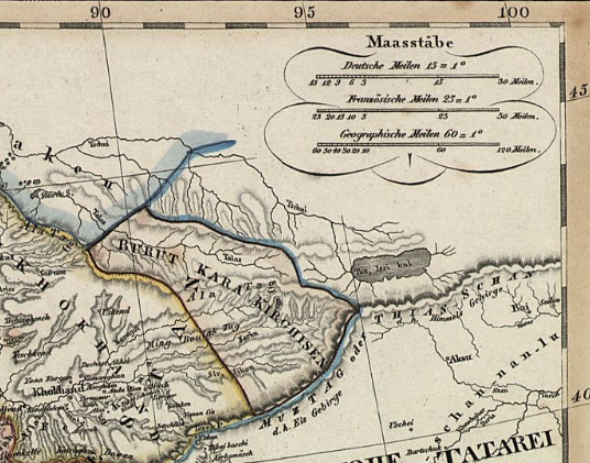
NKC map before 1859
Map of the North Kyrgyz Confederation in the early 19th century
- Date
- 1831–1859
- Mapmaker / publisher
- Stülpnagel, Friedrich von; Stieler, Adolf (Herausgeber/-in); Perthes, Justus (Herausgeber/-in)
- Place
- Central Asia
- Archive
- Wikimedia Commons
- Type
- map
- Original size
- 712 × 1,080 pixels
Public domain
Reason: its maker died long enough ago that the copyright has expired.
This status rests on the map's publication history, as researched by Wikimedia Commons. Check it before commercial use.
Read from: Commons licence category: PD Old; no CC BY, CC BY-SA, GFDL or deletion tag on the file page.
Credit line
"NKC map before 1859" (1831–1859). Stülpnagel, Friedrich von; Stieler, Adolf (Herausgeber/-in); Perthes, Justus (Herausgeber/-in), via Wikimedia Commons. Public domain. https://commons.wikimedia.org/wiki/File:NKC_map_before_1859_(cropped).jpgNeed maps for a whole project? Add Find Any Map to Claude and ask for this one by its id: 234239.
More like this
Map of Burut-Kyrgyz
1829 · Wikimedia Commons

General Map of Central Asia; Full Title: General map of Central Asia edited based on the best and the newest Russian and English sources. General map of Central Asia — III plate. Scale 1: 3 024 000; Dimension: 125 × 137 cm. "General map of Central Asia" is a large, detailed map produced in 1874 by t
1874 · Library of Congress

General Map of Central Asia; Full Title: General map of Central Asia edited based on the best and the newest Russian and English sources. General map of Central Asia — V plate. Scale 1: 3 024 000; Dimension: 125 × 137 cm. "General map of Central Asia" is a large, detailed map produced in 1874 by the
1874 · Plate 5 1874

General Map of Central Asia; Full Title: General map of Central Asia edited based on the best and the newest Russian and English sources. General map of Central Asia — IV plate. Scale 1: 3 024 000; Dimension: 125 × 137 cm. "General map of Central Asia" is a large, detailed map produced in 1874 by th
1874 · Plate 4 1874

General Map of Central Asia; Full Title: General map of Central Asia edited based on the best and the newest Russian and English sources. General map of Central Asia — Schematic View. Scale 1: 3 024 000; Dimension: 125 × 137 cm. "General map of Central Asia" is a large, detailed map produced in 1874
1874 · Library of Congress

Meyers b16 s0872a
1885–1890 · Wikimedia Commons

Stielers Handatlas 1891 68 Niger
1891 · Wikimedia Commons

Central Asia MKL Bd. 16 1890
1890 · Wikimedia Commons