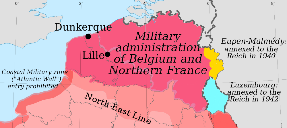

Military administration Belgium Northern France
Map of the German military administration of Belgium and Northern France.
- Date
- October 30, 2010
- Mapmaker / publisher
- Original creators were Eric Gaba (Sting) for the original blank map and Rama for the zones
- Archive
- Wikimedia Commons
- Type
- map
- Original size
- 1,000 × 448 pixels
Public domain
Reason: public domain: self.
This status rests on the map's publication history, as researched by Wikimedia Commons. Check it before commercial use.
Read from: Commons licence category: PD-self; no CC BY, CC BY-SA, GFDL or deletion tag on the file page.
Credit line
"Military administration Belgium Northern France" (October 30, 2010). Original creators were Eric Gaba (Sting) for the original blank map and Rama for the zones, via Wikimedia Commons. Public domain. https://commons.wikimedia.org/wiki/File:Military_administration_Belgium_Northern_France.pngNeed maps for a whole project? Add Find Any Map to Claude and ask for this one by its id: 23269.
More like this

France during German occupation (1940-1944).
January 9, 2011 · Wikimedia Commons

Military Administration in Serbia
July 31, 2011 · Wikimedia Commons

10May 16May Battle of Belgium
2009 · Wikimedia Commons

France 40-44
March 19, 2009 · Wikimedia Commons

German offensive in Belgium at 1940 (World war II.)
1940 · Wikimedia Commons

Western front 1914
1914 · Wikimedia Commons

Map of German annexations in Belgium 1940 (northern part) (Bundesarchiv Koblenz R 43 II 1404 a 0197)
May 29, 1940 · Wikimedia Commons

Map from "The Handbook on German Military Forces (TM-E 30-451)" a publication of the War departement, Military Intelligence Division, March 1945.
1945 · Wikimedia Commons