

Mapa de Borgia XV
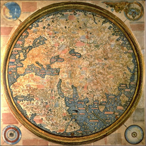
The Mappamondo Borgiano, anonymous 15th century map acquired by Cardinal Stefano Borgia in 1794 for the city of Velletri.
- Date
- 1794
- Archive
- Wikimedia Commons
- Type
- map
- Original size
- 4,692 × 4,506 pixels
Public domain
Reason: its maker died long enough ago that the copyright has expired.
This status rests on the map's publication history, as researched by Wikimedia Commons. Check it before commercial use.
Read from: Commons licence category: PD Old; no CC BY, CC BY-SA, GFDL or deletion tag on the file page.
Credit line
"Mapa de Borgia XV" (1794). Wikimedia Commons. Public domain. https://commons.wikimedia.org/wiki/File:Mapa_de_Borgia_XV.jpgNeed maps for a whole project? Add Find Any Map to Claude and ask for this one by its id: 144661.
More like this

Apographon descriptionis orbis terrae. circa medium Saec. XV tabulae aeneae Musei Borgiani Velitris consignatoe quod Camillus. Borgia,. summa fide, maximo que artificio expressum. eruditis spectandum proponit A. C. 1797
1450 · Wikimedia Commons

Apographon descriptionis orbis terrae, figuris et narratiunculis distinctae, manu germanica. circa medium saec. XV tabulae aeneae musei Borgiani Velitris consignatae quod. Camillus Joh. Paulli F. Borgia. spectandum proponst
1797 · 2 sheets

Apographon descriptionis Orbis terrae figuris et narratiunculis distinctae manu Germanica opere nigelliari discolorio circa medium saec. XV. tabulae aeneae Musei Borgiani Veltris consignatae.; Borgiakartan
Wikimedia Commons

Mapa de Borgia XV noroeste Peninsula Iberica
Wikimedia Commons

Tavola di Velletri
c. 1430 · Wikimedia Commons

Fragment of the Borgia Map showing the Iberian Peninsula
Wikimedia Commons

Nordenskiöld 1897 Plate 39 Mappa Mundi Auctoris Incerta Seculi XV Page298
December 31, 1897 · Wikimedia Commons
The Fra Mauro map. 1459.
1459 · Wikimedia Commons