

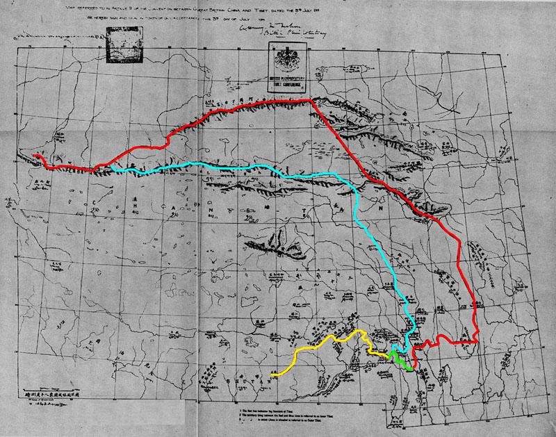
Map Referred to in Article 9 of Convention between Great Britain, China and Tibet, dated, the 3rd July 1914 Map No. 1
Qinghai
1945 Map Referred to in Article 9 of Convention between Britain China and Tibet from Tibetan Precis by Hugh Richardson The map shows; the frontier of Tibet (in red), and; the boundary between the Lhasa-controlled 'Outer Tibet' and Chinese-administered 'Inner Tibet' (in blue) as decided at the 1914 Simla Conference. Tibet and Britain signed the Convention, but not China. The southern portion of the red line up to the Isu Razi pass formed the boundary between Tibet and British Raj, later coming to be called the McMahon Line.
- Date
- 1945
- Place
- Qinghai
- Archive
- Wikimedia Commons
- Type
- map
- Original size
- 6,136 × 4,674 pixels
Public domain
Reason: public domain: India.
This status rests on the map's publication history, as researched by Wikimedia Commons. Check it before commercial use.
Read from: Commons licence category: PD India; no CC BY, CC BY-SA, GFDL or deletion tag on the file page.
Credit line
"Map Referred to in Article 9 of Convention between Great Britain, China and Tibet, dated, the 3rd July 1914 Map No. 1" (1945). Wikimedia Commons. Public domain. https://commons.wikimedia.org/wiki/File:Simla_Convention_map_by_Hugh_Richardson.jpgNeed maps for a whole project? Add Find Any Map to Claude and ask for this one by its id: 256355.
More like this

Map Referred to in Article 9 of Convention between Great Britain, China and Tibet, dated, the 3rd July 1914 Map No. 1
1945 · Kham

Frontier Proposals at the Simla Conference
1945 · Wikimedia Commons
Simla Accord Treaty 1914 Map1
1914 · Wikimedia Commons

Chinese Proposals for a Frontier Settlement 1915-1919
1945 · Wikimedia Commons

Simla Convention - contending claims in Kham
1945 · Wikimedia Commons

1945 McMahon Area--Map No 5 from Tibetan Precis
1945 · Wikimedia Commons

Sketch Map of Central and Eastern Tibet
1945 · Wikimedia Commons

McMahon Line Simla Accord Treaty 1914 Map1
May 1, 2006 · Wikimedia Commons