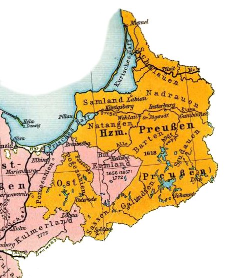

Map of East Prussia 1648
- Date
- 1905
- Place
- East Prussia
- Archive
- Wikimedia Commons
- Type
- atlas page
- Original size
- 478 × 554 pixels
Public domainsafest
Reason: its maker died more than 70 years ago, and a faithful scan of a flat work adds no new copyright.
Read from: Commons licence category: PD-Art (PD-old-70); no CC BY, CC BY-SA, GFDL or deletion tag on the file page; permission field: PD.
Credit line
"Map of East Prussia 1648" (1905). Wikimedia Commons. Public domain. https://commons.wikimedia.org/wiki/File:Map_of_East_Prussia_1648.jpgNeed maps for a whole project? Add Find Any Map to Claude and ask for this one by its id: 19610.
More like this

Map of East Prussia 1648
1905 · Wikimedia Commons

(Putzger) Prussia, 1415-1806
1902 · Wikimedia Commons

Brandenburg-Preussen 1688
1905 · Wikimedia Commons

F.W. Putzgers Historischer Schul-Atlas: zur alten, mittleren und neuen Geschichte: in 66 Haupt- und 63 Nebenkarten
Wikimedia Commons

Blaeu 1645 - Prussia
1645 · Wikimedia Commons

Deutschland im XVII. Jahrhundert (Putzger)
1902 · Wikimedia Commons

Atlas sive Cosmographicae Meditationes de Fabrica Mundi et Fabricati Figura. Denuo auctus, by Gerhard Mercator, Jodocus Hondius, and Hendrik Hondius. Published in Amsterdam by Hendricus Hondius, 1623.
1623 · Prussia

Cartes generales de toutes les parties du monde, ou les empires, monarchies, republiques, estats, peuples, &c. de l'Asie, de l'Afrique, de l'Europe, & de l'Americque, tant anciens que nouveaux, sont exactement remarqués, & distingués suivant leur estendue. Par le Sieur Sanson d'Abbeville, Geographe
1658 · Prussia, plate 220 of 388