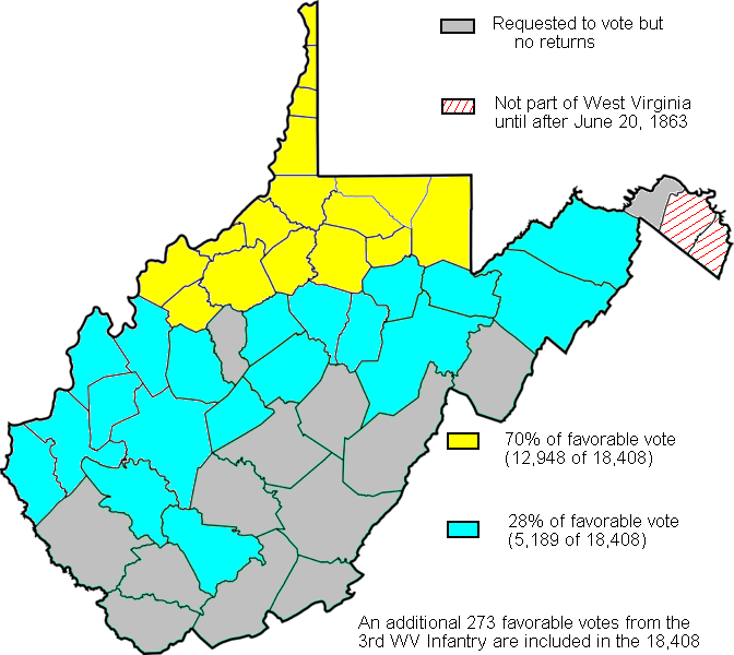

Map created based on the voting results of statehood referendum on Oct. 24, 1861 in West Virginia as compiled by Richard O. Curry in "A House Divided", pgs. 141-152.
- Date
- July 26, 2009
- Mapmaker / publisher
- Dubyavee
- Place
- the Secession votes
- Archive
- Wikimedia Commons
- Type
- map
- Original size
- 672 × 600 pixels
Public domain
Reason: public domain: self.
This status rests on the map's publication history, as researched by Wikimedia Commons. Check it before commercial use.
Read from: Commons licence category: PD-self; no CC BY, CC BY-SA, GFDL or deletion tag on the file page.
Credit line
"Map created based on the voting results of statehood referendum on Oct. 24, 1861 in West Virginia as compiled by Richard O. Curry in "A House Divided", pgs. 141-152." (July 26, 2009). Dubyavee, via Wikimedia Commons. Public domain. https://commons.wikimedia.org/wiki/File:WVStatehoodVote.pngNeed maps for a whole project? Add Find Any Map to Claude and ask for this one by its id: 1743.
More like this

West Virginia Counties which ratified the Virginia ordinance of Secession on May 23, 1861.
1861 · Wikimedia Commons

Map of western Virginia
1862 · Library of Congress

Lightburns Retreat September 1862
1862 · Wikimedia Commons

West Virginia state organization map
1979 · Library of Congress

Union Approach to Wytheville 1863
1863 · Library of Congress

Potomac River basin - Clarke, Frederick, and Highland Counties, Virginia, Berkeley, Grant, Hampshire, Hardy, Jefferson, Mineral, Morgan, and Pendleton Counties, West Virginia - forest cover types
1978 · Library of Congress

(Western Virginia from Petersburg to Warm Springs, showing the movement of the Union army, 1862)
1862 · Library of Congress

County map of Virginia and West Virginia
1863 · Library of Congress