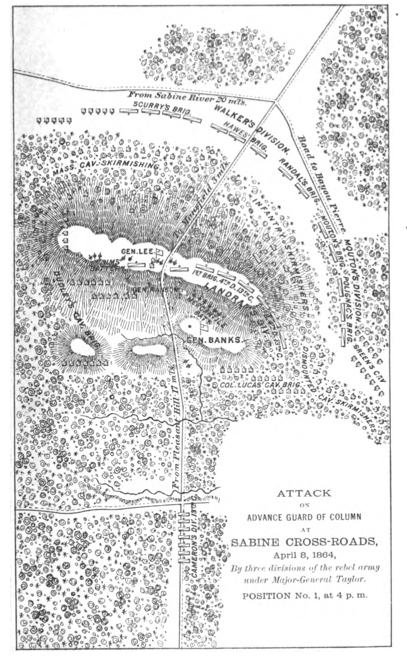

MansfieldMapFromBanksOfficaReport
- Date
- 1891
- Mapmaker / publisher
- United States War Department
- Place
- DeSoto Parish, Louisiana
- Archive
- Wikimedia Commons
- Type
- map
- Original size
- 407 × 658 pixels
Public domainsafest
Reason: a US government work.
Read from: Commons licence category: PD US Government; no CC BY, CC BY-SA, GFDL or deletion tag on the file page.
Credit line
"MansfieldMapFromBanksOfficaReport" (1891). United States War Department, via Wikimedia Commons. Public domain. https://commons.wikimedia.org/wiki/File:MansfieldMapFromBanksOfficaReport.jpgNeed maps for a whole project? Add Find Any Map to Claude and ask for this one by its id: 418.
More like this

RED RIVER CAMPAIGN MAP
1891 · Wikimedia Commons

No. 1. Map of Road from Pleasant Hill towards Mansfield. Surveyed by Lieut. E. C. Miles, Assistant Engr., April 7, 1864.
April 7, 1864 · U.S. National Archives

Battlefield of Pleasant Hill. Surveyed and Drawn by Lt. S. E. McGregory By Order of Maj. D. C. Houston, Chief Engineers, D.O.G. Department of the Gulf.
1861–1865 · U.S. National Archives

Port Hudson environs
1895 · Wikimedia Commons

Map Showing the Route of the Army During the Red River Campaign in the Spring of 1864. Surveys & Reconnoissances by Osw. Dietz, Civil Engineers, and Lieuts. Miles & McGregory.
1864 · U.S. National Archives

ATLAS OR PORT HUDSON MAP 1
1863 · Wikimedia Commons

(Shreveport, Louisiana, and vicinity).
1860 · Library of Congress

Baton Rouge to Port Hudson. Showing Position of 19th Army Corps, Maj. Gen. N. P. Banks, Com'd'g., on the 14th March 1863.
March 14, 1863 · U.S. National Archives