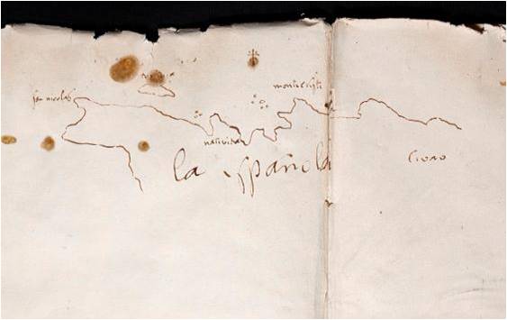

La Española 1493
Sketch of the northwest coast of Hispaniola island (nowadays Haiti), possibly made by Christopher Columbus or someone from his crew towards the end of his first voyage to the Indies in January 1493.
- Date
- c. 1493
- Mapmaker / publisher
- Anonymous, possibly Christopher Columbus or some other participant in his first trip to the Indies
- Place
- Hispaniola
- Archive
- Wikimedia Commons
- Type
- map
- Original size
- 563 × 355 pixels
Public domainsafest
Reason: its maker died more than 100 years ago, and a faithful scan of a flat work adds no new copyright.
Read from: Commons licence category: PD-Art (PD-old-100); no CC BY, CC BY-SA, GFDL or deletion tag on the file page.
Credit line
"La Española 1493" (c. 1493). Anonymous, possibly Christopher Columbus or some other participant in his first trip to the Indies, via Wikimedia Commons. Public domain. https://commons.wikimedia.org/wiki/File:La_Espa%C3%B1ola_1493.jpgNeed maps for a whole project? Add Find Any Map to Claude and ask for this one by its id: 295402.
More like this

Christopher Colombus map. Lisbon, workshop of Bartolomeo and Christopher Colombus, c.1490. This map cannot be definitely linked to Columbus.
c. 1490 · Wikimedia Commons

15thcenturyhispaniola v2
1606 · Wikimedia Commons

El Guárico, alias, el cavo frances, es una de las colonias y puertos qe. posseen los frances es en la parte occidental de la Ysla Española, una de las de Barlosto. en la América septemtrional.
1700 · Library of Congress

Drawing of Tortuga island during "Brother of the Coast" period, 17th century
Wikimedia Commons

Description del destricto dela Espanola / Antonio de Herrera y Tordesillas
1601–1615 · Wikimedia Commons

(Map showing Hispaniola, eastern portions of Cuba and Jamaica, western portion of Puerto Rico, and other adjacent islands).
1700 · Library of Congress

First map of the Spanish island by Pedro Mártir de Anglería
1511 · Wikimedia Commons

1500 map by Juan de la Cosa crop Caribbean
1500s · Wikimedia Commons