

Johnson’s Hindostan or British India.
Mumbai
A very nice example of A. J. Johnson’s 1865 map of India and Southeast Asia. Covers from the Indus River eastward to include all of India, Burma, Siam (Thailand), Laos, Cambodia, Malaysia (Malacca) and Vietnam (Tonquin and Chochin). Also includes parts of Pakistan, Nepal, China, Bhutan, Sumatra and Ceylon (Sri Lanka). Offers color coding according to country and region as well as notations regarding roadways, cities, towns, and river systems. Three inset maps focus on the Island of Bombay (Mumbai), Madras, and Calcutta. An view of the Government House and Treasury in Calcutta adorns the upper left corner. Features the fretwork style border common to Johnson’s atlas work from 1864 to 1869. Published by A. J. Johnson and Ward as plate number 96 in the 1865 edition of Johnson’s New Illustrated Family Atlas. This is the first edition of the Johnson Atlas to be attributed to Johnson exclusively.
- Date
- 1864
- Place
- Mumbai
- Archive
- Wikimedia Commons
- Type
- atlas page
- Original size
- 540 × 880 pixels
Public domainsafest
Reason: its maker died more than 100 years ago.
Read from: Commons licence category: PD-old-100-expired; no CC BY, CC BY-SA, GFDL or deletion tag on the file page.
Credit line
"Johnson’s Hindostan or British India." (1864). Wikimedia Commons. Public domain. https://commons.wikimedia.org/wiki/File:1865_Johnson%27s_map_of_Bombay.jpgNeed maps for a whole project? Add Find Any Map to Claude and ask for this one by its id: 255837.
More like this

Hindostan or British India.
1855 · Wikimedia Commons

India or Hindostan.
1855 · Wikimedia Commons

Map of Hindoostan, Farther India, China, and Tibet.
1860 · Wikimedia Commons
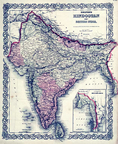
Map of British India, 1855. Published by G. W. and C. B. Colton and Company in New York, 1855. It was derived from an earlier wall map of the world produced by Colton and D. Griffing Johnson. Covers t
1855 · Wikimedia Commons

Map of British India and the Straits Settlements
1860 · Wikimedia Commons

Ca. 1860 map of India and neighbouring countries
c. 1860 · Wikimedia Commons

British India John Tallis
1851 · Wikimedia Commons

Hindoustan ou Inde en deca du Gange et Inde Transgangetique par V. Levasseur Geographe.
1852 · Wikimedia Commons