

Gau Oberschlesien-Ostoberschlesien
File:Gau Oberschlesien.png with imposed borders of Ostoberschlesien:; 1 - Polish Voivodeship Silesia before 1939 within borders of Germany before 1920; 2 - Polish Voivodeship Silesia before 1939 within borders of Austria Germany before 1920 (Cieszyn Silesia); 3 - so called Zaolzie - part of Cieszyn Silesia annexed from Poland in 1938, after 1920 within Czechoslovakia (in German Olsa-Gebiet, but in WW2 the term would be extended for the whole Cieszyn County); 4 - new "Ostoberschlesien", before 1939 in Voivodeships Kielce and Kraków
- Date
- 1943
- Mapmaker / publisher
- Reichsstelle für das Schul- und Unterrichtsschrifttum
- Place
- Nazi Germany
- Archive
- Wikimedia Commons
- Type
- map
- Original size
- 1,222 × 1,693 pixels
Public domain
Reason: its maker died long enough ago that the copyright has expired.
This status rests on the map's publication history, as researched by Wikimedia Commons. Check it before commercial use.
Read from: Commons licence category: PD Old; no CC BY, CC BY-SA, GFDL or deletion tag on the file page.
Credit line
"Gau Oberschlesien-Ostoberschlesien" (1943). Reichsstelle für das Schul- und Unterrichtsschrifttum, via Wikimedia Commons. Public domain. https://commons.wikimedia.org/wiki/File:Gau_Oberschlesien-Ostoberschlesien.pngNeed maps for a whole project? Add Find Any Map to Claude and ask for this one by its id: 23633.
More like this

Gau Oberschlesien
1943 · Wikimedia Commons
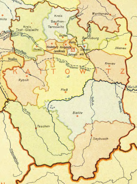
Regierungsbezirk Kattowitz
1943 · Wikimedia Commons

SHEAF Handbook SA of the NSDAP 0366 Nazi Germany map Sturmabteilung SA GROUPS WEHRKREIS HQ Number (Uniform plate NSDAP Organisationsbuch 0000) Uncredited artwork Public domain (merged image composite)
1945 · Wikimedia Commons

Partition of Czechoslovakia
1938 · Wikimedia Commons

Map from "The Handbook on German Military Forces (TM-E 30-451)" a publication of the War departement, Military Intelligence Division, March 1945.
1945 · Wikimedia Commons

German part of Silesia
Wikimedia Commons

Podręcznik geografii ojczystej zawierający treściwy opis ziem dawnej Polski z uwzględnieniem dzisiejszych stosunków i podziału politycznego: dodana krótka wiadomość o Czechach i Rusinach.
Wikimedia Commons

Deutschesreich1939 (cropped to Czechoslovakia)
Wikimedia Commons