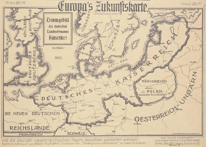

Europas Zukunftskarte 1915
Alban Rumann, Europa's Zukunftskarte, Berlin: Fritz Steidl, 1915, lithography on paper, 367 x 564 mm, reverse side. "Europe's future map. On obverse: A dream image of our enemies! How the French, Russians and English imagined the Central European borders in 1915 and on reverse: how the German-Austrian armies will shape them! Dream vision of the German militiaman Kutschke!".
- Date
- 1915
- Mapmaker / publisher
- Alban Rumann
- Place
- Europe
- Archive
- Wikimedia Commons
- Type
- map
- Original size
- 693 × 493 pixels
Public domainsafest
Reason: its maker died more than 70 years ago, and a faithful scan of a flat work adds no new copyright.
Read from: Commons licence category: PD-Art (PD-old-70); no CC BY, CC BY-SA, GFDL or deletion tag on the file page.
Credit line
"Europas Zukunftskarte 1915" (1915). Alban Rumann, via Wikimedia Commons. Public domain. https://commons.wikimedia.org/wiki/File:Europas_Zukunftskarte_1915.jpgNeed maps for a whole project? Add Find Any Map to Claude and ask for this one by its id: 21748.
More like this

Humoristische Karte von Europa im Jahre 1914
1914 · Wikimedia Commons

Satyrische Europa Karte, Weltkrieg 1914 Zeichnung u. Entwurf, E. Zimmermann
1914 · Wikimedia Commons

Humoristische Karte von Europa im Jahre 1914
1914 · Wikimedia Commons

French World War I anti-German propaganda - Le Plan Pangermaniste
c. 1915 · Wikimedia Commons

Europäische Treibjagd
1914 · Wikimedia Commons

Satyrische Europa Karte Weltkrieg 1914 / Zeichnung v. Entwurf, E. Zimmermann, Hamburg, 6.
1914 · Library of Congress

Neu-Geographie-Propaganda-Postkarte
1915 · Wikimedia Commons

Humoristische Karte Europa 1870
c. 1870 · Wikimedia Commons