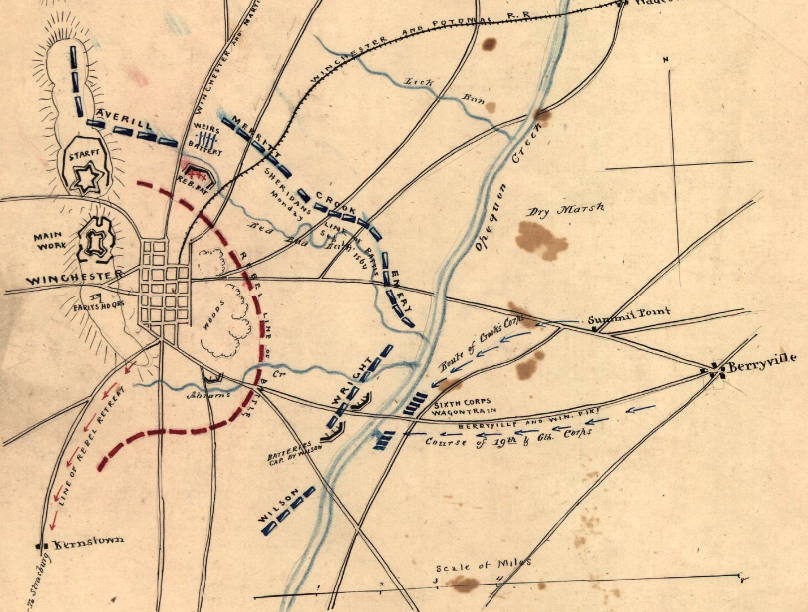

3rd Winchester Final Stand
On September 19, 1864, Philip Sheridan's Army of the Shenandoah defeated Jubal Early's Army of the Valley at Winchester, Virginia, in the American Civil War. Sheridan attacked from multiple sides and nearly surrounded Early's army. NOTE: the positions of Red Bud Run and Abrams Creek are doubtful. Emory was south of Red Bud Run. Abrams Creek is south of the Berryville Pike and separated Wright and Wilson—compare to other maps in this category.
- Date
- September 19, 1864
- Mapmaker / publisher
- Major Jedediah Hotchkiss (1828-1899), a cartographer for the Confederate States of America
- Archive
- Library of Congress (via Wikimedia Commons)
- Type
- map
- Original size
- 808 × 612 pixels
Public domainsafest
Reason: its maker died more than 70 years ago.
Read from: Commons licence category: PD-old-70-expired; no CC BY, CC BY-SA, GFDL or deletion tag on the file page.
Credit line
"3rd Winchester Final Stand" (September 19, 1864). Major Jedediah Hotchkiss (1828-1899), a cartographer for the Confederate States of America. Library of Congress, Geography and Map Division, via Wikimedia Commons. Public domain. https://commons.wikimedia.org/wiki/File:3rd_Winchester_Final_Stand.pngNeed maps for a whole project? Add Find Any Map to Claude and ask for this one by its id: 1778.
More like this

3rd Winchester Map Noon
1914 · Library of Congress

3rd Winchester 2 Crook Flank
1895 · Wikimedia Commons

3rd Winchester Terrain and Positions
1895 · Wikimedia Commons

After 3rd Winchester
1912 · Library of Congress

In the American Civil War's Third Battle of Winchester that occurred on September 19, 1864, Union cavalry (including Averell's 2nd Division) attacked from the north.
1873 · Library of Congress

3rd Winchester 1 Infantry Beg
1895 · Wikimedia Commons

3rd Winchester Final Stand US Gov
1873 · Wikimedia Commons

3rd Winchester XIX Corps Front
1873 · Library of Congress