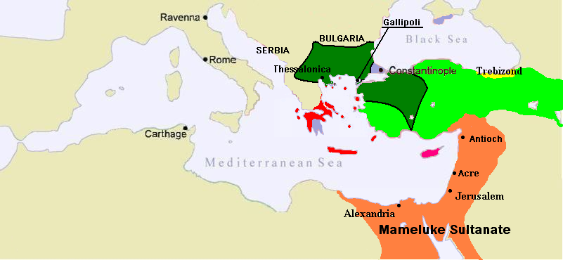

1389 Mediterranean Sea
Map of the Middle East c.1389. Serbia has been reduced to vassal status and Byzantium (purple) consists only of Constantinople and a few outer posts. Following the occupation of Gallipoli, the Ottomans (Dark Green) rapidly spread across the Balkans giving them a major advantage over their Turkic (Green) rivals in Anatolia.
- Date
- June 15, 2007
- Place
- Burji dynasty
- Archive
- Wikimedia Commons
- Type
- map
- Original size
- 801 × 370 pixels
Public domain
Reason: public domain: user.
This status rests on the map's publication history, as researched by Wikimedia Commons. Check it before commercial use.
Read from: Commons licence category: PD-user; no CC BY, CC BY-SA, GFDL or deletion tag on the file page.
Credit line
"1389 Mediterranean Sea" (June 15, 2007). Wikimedia Commons. Public domain. https://commons.wikimedia.org/wiki/File:1389_Mediterranean_Sea.PNGNeed maps for a whole project? Add Find Any Map to Claude and ask for this one by its id: 246136.
More like this

1350 Mediterranean Sea
June 13, 2007 · Wikimedia Commons

Empire byzantin 1389
February 17, 2012 · Wikimedia Commons

1263 Mediterranean Sea
June 14, 2007 · Wikimedia Commons

C. 1355 Southeastern Europe
c. 1911 · Wikimedia Commons

Map of the Balkans in 1389.
November 27, 2023 · Wikimedia Commons

C. 1355 Eastern Roman Empire
1888–1897 · Wikimedia Commons

1328 Mediterranean Sea
June 14, 2007 · Wikimedia Commons

The Ottoman Empire 1451-1481
c. 1911 · Wikimedia Commons