

1350 Mediterranean Sea
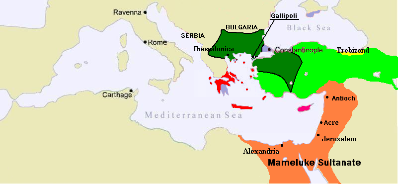
Map of the Middle East c.1350. Byzantium has lost her cities in Asia Minor and Epirus has been reduced significantly by Serbia. Ottoman lands are in dark green; other Turks in light green and purple Byzantium. Blue (uncertain borders) is Cilicia. Red are Latin holdings.
- Date
- June 13, 2007
- Place
- Bahri dynasty
- Archive
- Wikimedia Commons
- Type
- map
- Original size
- 801 × 370 pixels
Public domain
Reason: public domain: user.
This status rests on the map's publication history, as researched by Wikimedia Commons. Check it before commercial use.
Read from: Commons licence category: PD-user; no CC BY, CC BY-SA, GFDL or deletion tag on the file page.
Credit line
"1350 Mediterranean Sea" (June 13, 2007). Wikimedia Commons. Public domain. https://commons.wikimedia.org/wiki/File:1350_Mediterranean_Sea.PNGNeed maps for a whole project? Add Find Any Map to Claude and ask for this one by its id: 246137.
More like this

1263 Mediterranean Sea
June 14, 2007 · Wikimedia Commons
1389 Mediterranean Sea
June 15, 2007 · Wikimedia Commons

C. 1355 Southeastern Europe
c. 1911 · Wikimedia Commons

1328 Mediterranean Sea
June 14, 2007 · Wikimedia Commons

C. 1355 Eastern Roman Empire
1888–1897 · Wikimedia Commons

Empire byzantin 1389
February 17, 2012 · Wikimedia Commons

Byzantine empire 1355
1911 · Wikimedia Commons

Balkans and Anatolia in 1354
November 17, 2024 · Wikimedia Commons