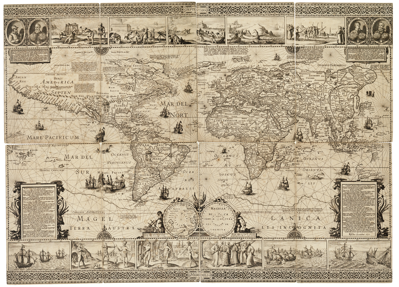

World RMG K1010
world The sheet is a composite of eight sections. Engraving, pasted onto card. Scale: circa1:35,000,000. Cylindrical projection, borders graduated for latitude and longitude, rhumb lines. Pictorial borders at top and bottom illustrate events from Dutch expeditions, of William Barentsz's voyage in search of a North East Passage, and Olivier van Noort's circumnavigation. The toute of Van Noort's voyage is shown on the map itself, labelled 'Exitus Oliverij a Noordt A. 1598' and 'Reditus Oliverij a Noordt A. 1601.' In the top corners are portraits of Magellan, Drake, Cavendish and Noort. Although the Australian continent is shown, this is done according to voyages up to that of Leewin and Nuyts in 1627. The results of tasman's voyage (seen in Blaeu's world map of 1648) is not represented. Spizbergen is redrawn on the basis of Henricus Hondius' polar map of 1636, and parts of North America include details from observations in the 1630s. This inludes a note on tides in James Bay (Hudsons Bay) dated 1631. This map is a revised edition of an original by Cornelius Claeszoon published in four parts about 1604, of which no copies are now known. There is one other extant copy of this 1650 m
- Date
- 1650
- Mapmaker / publisher
- Claes Janszoon Visscher; Nicolay Cornelis Claesz
- Archive
- Wikimedia Commons
- Type
- chart
- Original size
- 1,280 × 922 pixels
Public domainsafest
Reason: its maker died more than 100 years ago.
Read from: Commons licence category: PD-old-100-expired; no CC BY, CC BY-SA, GFDL or deletion tag on the file page.
Credit line
"World RMG K1010" (1650). Claes Janszoon Visscher; Nicolay Cornelis Claesz, via Wikimedia Commons. Public domain. https://commons.wikimedia.org/wiki/File:World_RMG_K1010.jpgNeed maps for a whole project? Add Find Any Map to Claude and ask for this one by its id: 21462.
More like this

Nova totius terrarum orbis tabula auctore F. de Wit RMG F8117
1660 · Wikimedia Commons

Nova totius terrarum orbis geographica ac hydrographica tabula RMG F0410
1606 · Wikimedia Commons

A new and accurat map of the world drawn according to ye truest descriptions latest discoveries and best observations yt have been made by English or strangers. 1626. (at foot) Are to be sold in Pops-head Alle by Geor- RMG F0331
1626 · Wikimedia Commons

A new and accurat map of the world drawn according to ye truest descriptions latest discoveries and best observations yt have been made by English or strangers. 1626. (at foot) Are to be sold in Pops-head Alle by Geor- RMG F7409-001
1626 · Wikimedia Commons

A new and accurat map of the world drawn according to ye truest descriptions latest discoveries and best observations yt have been made by English or strangers. 1626. (at foot) Are to be sold in Pops-head Alle by Geor- RMG L7212-001
1626 · Wikimedia Commons

Nova totius terrarum orbis tabula RMG F8175
c. 1680 · Wikimedia Commons

Nova delineatio totius orbis terrarum RMG F8090
1663 · Wikimedia Commons

Nova et Exacta Asiae Geographica Descriptio, auct G. I. Blaeu RMG L4968-001
1657 · Wikimedia Commons