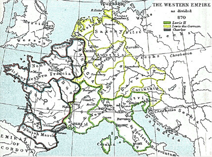

Western Empire-Europe870
Frank king Charlemagne's kingdom survived the leader and covered much of Western Europe from 795 until 843 when a treaty split it amongst his grandsons: Central Franks ruled by w:Lothar I (green), East Franks ruled by w:Louis the German (yellow), and w:Charles the Bald led West Franks (purple). This particular map is from the Atlas to Freeman's Historical Geography, edited by J.B. Bury, Longmans Green and Co. Third Edition 1903. It is in the public domain and you may download it or print it for any use.
- Date
- 1903
- Mapmaker / publisher
- J.B. Bury
- Place
- Treaty of Verdun
- Archive
- Wikimedia Commons
- Type
- atlas page
- Original size
- 428 × 317 pixels
Public domain
Reason: its maker died long enough ago that the copyright has expired.
This status rests on the map's publication history, as researched by Wikimedia Commons. Check it before commercial use.
Read from: Commons licence category: PD Old; no CC BY, CC BY-SA, GFDL or deletion tag on the file page.
Credit line
"Western Empire-Europe870" (1903). J.B. Bury, via Wikimedia Commons. Public domain. https://commons.wikimedia.org/wiki/File:Western_Empire-Europe870.JPGNeed maps for a whole project? Add Find Any Map to Claude and ask for this one by its id: 254688.
More like this

C. 843 Division of Carolingian Empire
c. 1886 · Wikimedia Commons

Partage de l'Empire carolingien au Traité de Verdun en 843
Wikimedia Commons

EB1911 Europe - Western Empire after the Partition of Mersen 870
1911 · Wikimedia Commons

C. 814 Frankish Kingdoms
c. 1911 · Wikimedia Commons

The Frankish Empire at the death of Charlemagne, in 814.
1886 · Wikimedia Commons

De karolingska rikena efter delningen i verdun 843
1880 · Wikimedia Commons

Mitteleuropa zur Zeit der Karolinger
1886 · Wikimedia Commons

C. 888 Europe
c. 1911 · Wikimedia Commons