

The Old Customs House (B) in Knoxville, Tennessee, USA, as it appeared in 1886. Letters "T" and "S" on the lower left are the Methodist Episcopal Church and the Methodist Episcopal Church, South, resp
- Date
- 1886
- Mapmaker / publisher
- H. Wellge (drawing); Beck and Pauli (lithograph)
- Archive
- Library of Congress (via Wikimedia Commons)
- Type
- bird's-eye view
- Original size
- 506 × 343 pixels
Public domain
Reason: a US government work.
This status rests on the map's publication history, as researched by Wikimedia Commons. Check it before commercial use.
Read from: Commons licence category: PD US; no CC BY, CC BY-SA, GFDL or deletion tag on the file page.
Credit line
"The Old Customs House (B) in Knoxville, Tennessee, USA, as it appeared in 1886. Letters "T" and "S" on the lower left are the Methodist Episcopal Church and the Methodist Episcopal Church, South, resp" (1886). H. Wellge (drawing); Beck and Pauli (lithograph). Library of Congress, Geography and Map Division, via Wikimedia Commons. Public domain. https://commons.wikimedia.org/wiki/File:Knoxville-customs-house-1886-tn1.jpgNeed maps for a whole project? Add Find Any Map to Claude and ask for this one by its id: 14555.
More like this

"Knoxville, Tenn., County Seat of Knox County, 1886," a bird's eye view of Knoxville, Tennessee, USA, as drawn in 1886.
1886 · Library of Congress

Knoxville, Tenn. county seat of Knox County 1886.
1886 · Library of Congress

The railroad yard at the north end of Gay Street, as it appeared on an 1886 map of Knoxville, Tennessee, USA. The building labelled "D" was the depot and offices for the East Tennessee, Virginia & Geo
1886 · Library of Congress

Factories in the Mechanicsville section of Knoxville, Tennessee, USA, as they appeared on an 1886 map of the city. Number "4" is the Evans & Co. Marble Works, number "5" is the Phoenix Marble Works, a
1886 · Library of Congress
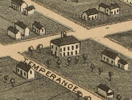
The intersection of Clinch and Temperance streets in Knoxville, Tennessee, United States, in 1871. Temperance Hall, a popular gathering place, is at the center. This area was near the modern intersect
1871 · Library of Congress

"Bird's Eye View of the City of Knoxville, Knox County, Tennessee, 1871," a map of Knoxville, Tennessee, USA, published in 1871.
1871 · Library of Congress

The old Gay Street Bridge, or "Saulpaw" bridge, as it appeared on an 1886 map of Knoxville, Tennessee, USA. This bridge was a wooden Howe truss bridge, built by G. W. Saulpaw in 1880. It was replaced
1886 · Library of Congress

Detail of an 1871 map showing the intersection of Main Street and Gay Street in Knoxville, Tennessee, USA. The old Knox County Courthouse is the building on the extreme left (with the cupola). The Man
1871 · Library of Congress