

Stielers Handatlas 1891 68 Damagaram crop
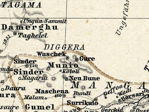
Crop of a German 1891 atlas, West Africa showing what is today south east Niger and north east Nigeria. Names are German spelling, often archaic. Map is centered on the Sultanate of Damagaram, a vasalate of the Bornu state. Yellow lines mark border between Bornu and the allied emirates of the Sokoto Caliipate.
- Date
- 1891
- Mapmaker / publisher
- derivative work: T L Miles ( talk )
- Place
- Africa
- Archive
- Wikimedia Commons
- Type
- map
- Original size
- 811 × 599 pixels
Public domainsafest
Reason: its maker died more than 100 years ago.
Read from: Commons licence category: PD-old-100-expired; no CC BY, CC BY-SA, GFDL or deletion tag on the file page.
Credit line
"Stielers Handatlas 1891 68 Damagaram crop" (1891). derivative work: T L Miles ( talk ), via Wikimedia Commons. Public domain. https://commons.wikimedia.org/wiki/File:Stielers_Handatlas_1891_68_Damagaram_crop.jpgNeed maps for a whole project? Add Find Any Map to Claude and ask for this one by its id: 237016.
More like this

Stielers Handatlas 1891 68 Niger
1891 · Wikimedia Commons

Stielers Handatlas 1891 68 Tsad-See
1891 · Wikimedia Commons

Stielers Handatlas 1891 68 Karakara
1891 · Wikimedia Commons

Stielers Handatlas 1891 68 Magaria
1891 · Wikimedia Commons

Stielers Handatlas 1891 68 Sinder
1891 · Wikimedia Commons
Stielers Handatlas 1891 68 Gure
1891 · Wikimedia Commons

Stielers Handatlas 1891 68 Taua
1891 · Wikimedia Commons

Stielers Handatlas 1891 68 Tessaua
1891 · Wikimedia Commons