

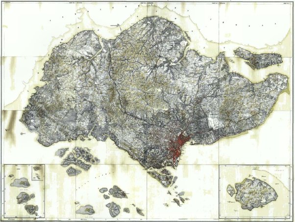
Singapore Railways, 1907
Map of Singapore Railways, 1907
- Date
- 1907
- Mapmaker / publisher
- cartographer
- Place
- Singapore
- Archive
- Wikimedia Commons
- Type
- map
- Original size
- 572 × 1,036 pixels
Public domainsafest
Reason: its maker died more than 70 years ago.
Read from: Commons licence category: PD-old-70-expired; no CC BY, CC BY-SA, GFDL or deletion tag on the file page.
Credit line
"Singapore Railways, 1907" (1907). cartographer, via Wikimedia Commons. Public domain. https://commons.wikimedia.org/wiki/File:Singapore_Railways,_1907.jpgNeed maps for a whole project? Add Find Any Map to Claude and ask for this one by its id: 242501.
More like this

Map of Singapore (Baedeker, 1914) cropped
1914 · Wikimedia Commons

Guide map of Singapore Town from The Stranger's Guide to Singapore
1890 · Wikimedia Commons

1942 Japanese pictorial map of Singapore
1942 · Wikimedia Commons

Baedeker London 1907
1907 · Wikimedia Commons

Map of Singapore (Baedeker, 1914)
1914 · Wikimedia Commons

Detail of a map of Malaya (British Malaya) by the Surveyor General of the Federated Malay States and Straits Settlements, showing Singapore (part of the Straits Settlements) shaded in red and Johor (o
1925 · Wikimedia Commons
A composite map of Singapore with islands (including insets), made up of 16 small-scale maps, by the Surveyor General of the Federated Malay States and Straits Settlements. The inset on the right show
1924 · Wikimedia Commons

Andrees Handatlas - Singapore-Strasse
Wikimedia Commons