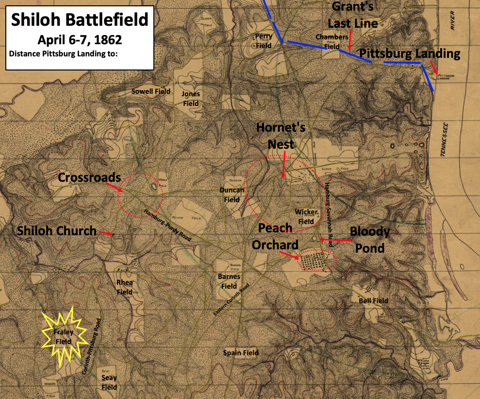

Shiloh battlefield topical map
This is an image from a Shiloh National Military Park map, and TwoScarsUp has added more labels to make it easier to read. The map shows places of importance, including field names, on the Shiloh battlefield. The battle took place on April 6 & 7, 1862. The locations of the Crossroads, Peach Orchard, Hornet's Nest, and Grant's Last Line are based on maps in "Shiloh and the Western Campaign of 1862" by O. Edward Cunningham, including the maps on pages 220, 239, 267, and 328. The location of the Bloody Pond is shown on a map on page 14 of Jeff Shaara's "Civil War Battlefields".
- Date
- 1920
- Mapmaker / publisher
- The file, created in 1920, is from the Shiloh National Military Park. Additional labels added by TwoScarsUp
- Place
- Tennessee
- Archive
- Library of Congress (via Wikimedia Commons)
- Type
- map
- Original size
- 989 × 821 pixels
Public domainsafest
Reason: its US copyright has expired (published before 1931).
Read from: Commons licence category: PD US expired; no CC BY, CC BY-SA, GFDL or deletion tag on the file page.
Credit line
"Shiloh battlefield topical map" (1920). The file, created in 1920, is from the Shiloh National Military Park. Additional labels added by TwoScarsUp. Library of Congress, Geography and Map Division, via Wikimedia Commons. Public domain. https://commons.wikimedia.org/wiki/File:Shiloh_battlefield_topical_map.pngNeed maps for a whole project? Add Find Any Map to Claude and ask for this one by its id: 1573.
More like this

Shiloh battlefield topical map V2
1920 · Library of Congress

Map of the battlefield of Shiloh.
1920 · Library of Congress

This image from a West Point atlas has been rotated so north is at the top, and TwoScarsUp has added more labels to make it easier to read. (Note that the "North arrow" is not perfectly straight "up"—
1959 · United States Military Academy, Department of Military Art and Engineering, with Colonel Vincent J. Esposito as the chief editor. Additional labels added by TwoScarsUp

Union Camps at Shiloh
1959 · Library of Congress

This image is from a West Point atlas that has been rotated so north is at the top, and TwoScarsUp has added more labels to make it easier to read. (Note that the "North arrow" is not perfectly straig
1959 · Library of Congress

General Buell's map of the battle-field of Shiloh. (April 6-7, 1862)
1886 · Library of Congress

Battle of Shiloh battle map, 1865
1865 · Library of Congress

Map of the field of Shiloh. April 6 (1862).
1862 · Library of Congress