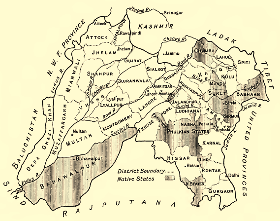

Punjab-Districts 1911
Map of the Districts and some Indian Princely States (Bahawalpur, Sirmur, Suket, Chamba etc.) of the Punjab, 1911
- Date
- 1913
- Mapmaker / publisher
- Sir Henry
- Place
- India
- Archive
- Wikimedia Commons
- Type
- map
- Original size
- 569 × 448 pixels
Public domain
Reason: its maker died long enough ago that the copyright has expired.
This status rests on the map's publication history, as researched by Wikimedia Commons. Check it before commercial use.
Read from: Commons licence category: PD Old; no CC BY, CC BY-SA, GFDL or deletion tag on the file page.
Credit line
"Punjab-Districts 1911" (1913). Sir Henry, via Wikimedia Commons. Public domain. https://commons.wikimedia.org/wiki/File:Punjab-Districts_1911.pngNeed maps for a whole project? Add Find Any Map to Claude and ask for this one by its id: 255753.
More like this

Map of Punjab Province, British India, published in 'The Panjab, North-West Frontier Province and Kashmir'
1916 · Wikimedia Commons

Religious distribution map of Punjab Province, British India, published in 'The Panjab, North-West Frontier Province and Kashmir'
1916 · Wikimedia Commons

Map showing the change in population (increases & decreases) of Punjab Province, British India, published in 'The Panjab, North-West Frontier Province and Kashmir'
1916 · Wikimedia Commons

Skeleton district map of Punjab Province, British India, published in 'The Panjab, North-West Frontier Province and Kashmir'
1916 · Wikimedia Commons

Linguistic map of the Punjab Province, North-West Frontier Province, and princely-state of Jammu and Kashmir, British India, published in 'The Panjab, North-West Frontier Province and Kashmir'
1916 · Wikimedia Commons

Ludhiana District 1911
1911 · Wikimedia Commons

Punjab in 1912
1912 · Wikimedia Commons

Map of Hisar district (with portions of the Phulkian States, etc.) of Punjab Province, British India, published in 'The Panjab, North-West Frontier Province and Kashmir'
1916 · Wikimedia Commons