
Pozieres map J00158
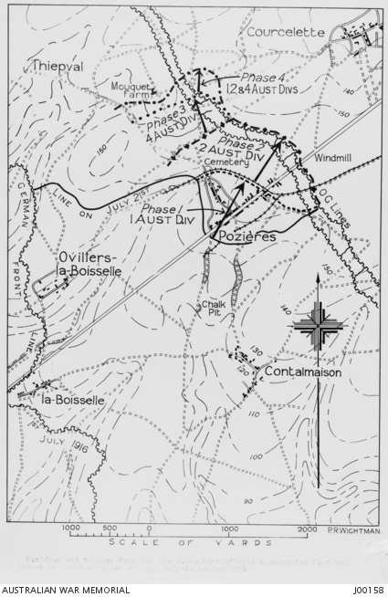
A map of Pozieres and Mouquet Farm, Somme, showing the four main phases in the Australian attack, July - September, 1916.
- Date
- 1916
- Mapmaker / publisher
- From a tracing by Lieutenant Peter Rigby Wightman
- Archive
- Wikimedia Commons
- Type
- map
- Original size
- 425 × 654 pixels
Public domain
Reason: public domain: Australia.
This status rests on the map's publication history, as researched by Wikimedia Commons. Check it before commercial use.
Read from: Commons licence category: PD-Australia; no CC BY, CC BY-SA, GFDL or deletion tag on the file page.
Credit line
"Pozieres map J00158" (1916). From a tracing by Lieutenant Peter Rigby Wightman, via Wikimedia Commons. Public domain. https://commons.wikimedia.org/wiki/File:Pozieres_map_J00158.jpgNeed maps for a whole project? Add Find Any Map to Claude and ask for this one by its id: 22878.
More like this

Somme Front, July to October 1916
1916 · Wikimedia Commons

Map showing villages south of the Somme west of Peronne, 1916
1916 · Wikimedia Commons

Battle of the Nek - map of objectives
Wikimedia Commons

Battle of the Nek - map of objectives
July 20, 1915 · Wikimedia Commons

Map #1 to accompany 1st ANZAC Corps Order #117
1917 · Wikimedia Commons

Somme attack fronts, 1916
1916 · Wikimedia Commons

Battle of Menin Road- Australian situation map
1917 · Wikimedia Commons

Map of the 42nd (East Lancashire) Division's attack on the Hindenburg Line on September 27 1918.
c. 1919 · Wikimedia Commons