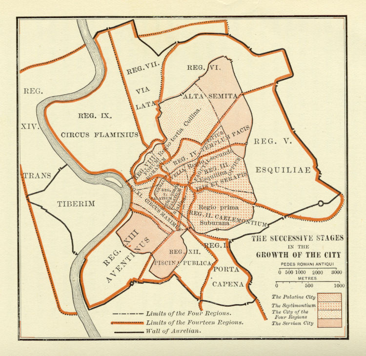

Platner - Ancient Rome city growth
Retrieved from from Samuel Ball Platner: The Topography and Monuments of Ancient Rome (Boston: Allyn and Bacon, 1904). Stated to be in the public domain.
- Date
- November 29, 2005
- Place
- Aurelian Walls
- Archive
- Wikimedia Commons
- Type
- map
- Original size
- 750 × 729 pixels
Public domain
Reason: a US government work.
This status rests on the map's publication history, as researched by Wikimedia Commons. Check it before commercial use.
Read from: Commons licence category: PD US; no CC BY, CC BY-SA, GFDL or deletion tag on the file page; Commons tags it as a US government work, but its record names no government maker.
Credit line
"Platner - Ancient Rome city growth" (November 29, 2005). Wikimedia Commons. Public domain. https://commons.wikimedia.org/wiki/File:Platner_-_Ancient_Rome_city_growth.jpgNeed maps for a whole project? Add Find Any Map to Claude and ask for this one by its id: 20223.
More like this

Roma quadrata - Palatina, Vierregionenstadt und Servianische Stadt
1902 · Wikimedia Commons

The Topography and Monuments of Ancient Rome cropped
1911 · Wikimedia Commons

The Topography and Monuments of Ancient Rome
Wikimedia Commons

Roma Plan
1886 · Wikimedia Commons

The Growth of Roman Power in Italy Historical Atlas by William R. Shepherd, 1911. Courtesy of the University of Texas Libraries, The University of Texas at Austin. From The Historical Atlas by William
1911 · Wikimedia Commons

Roma Plan bw
1886 · Wikimedia Commons

Map of Republican Rome by William R Shepherd (died 1934) edited
1934 · Wikimedia Commons

The Topography and Monuments of Ancient Rome QNO
1911 · Wikimedia Commons