

Planta da cidade de Porto-Allegre (Cartográfico) — com a linha de trincheiras e fortificações que lhe tem servido de defesa desde o memoravel dia 15 de junho de 1836, com as. por L. P. Dias
- Date
- 1839
- Mapmaker / publisher
- L. P. Dias
- Place
- Porto Alegre
- Archive
- Wikimedia Commons
- Type
- map
- Original size
- 3,516 × 4,731 pixels
Public domain
Reason: its maker died long enough ago that the copyright has expired.
This status rests on the map's publication history, as researched by Wikimedia Commons. Check it before commercial use.
Read from: Commons licence category: PD Old; no CC BY, CC BY-SA, GFDL or deletion tag on the file page.
Credit line
"Planta da cidade de Porto-Allegre (Cartográfico) — com a linha de trincheiras e fortificações que lhe tem servido de defesa desde o memoravel dia 15 de junho de 1836, com as. por L. P. Dias" (1839). L. P. Dias, via Wikimedia Commons. Public domain. https://commons.wikimedia.org/wiki/File:Planta_da_cidade_de_Porto-Allegre_(Cartogr%C3%A1fico)_%E2%80%94_com_a_linha_de_trincheiras_e_fortifica%C3%A7%C3%B5es_que_lhe_tem_servido_de_defesa_desde_o_memoravel_dia_15_de_junho_de_1836,_com_as..._por_L._P._Dias.jpgNeed maps for a whole project? Add Find Any Map to Claude and ask for this one by its id: 307186.
More like this
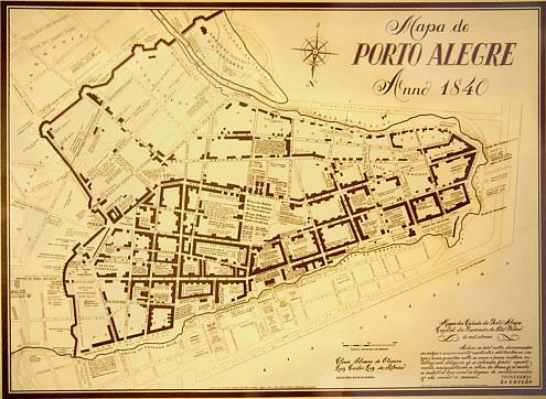
mapa de Porto Alegre em 1840
1840 · Wikimedia Commons

Planta da cidade de S. Sebastião do Rio de Janeiro
1808 · Library of Congress

Planta da cidade de Corrientes
1869 · Wikimedia Commons

Planta do Canal e Porto de Santos. Autoria de J. G. Thr. Litografia do Arquivo Militar. Escala 1 - 4800. 1882 - 1 (2), Acervo do Museu Paulista da USP
1882 · Wikimedia Commons

Planta do Canal e Porto de Santos. Autoria de J. G. Thr. Litografia do Arquivo Militar. Escala 1 - 4800. 1882 - 1 (1), Acervo do Museu Paulista da USP
1882 · Wikimedia Commons

Planta da cidade do Rio de Janeiro
1858 · Library of Congress

Carta Demonstrativa do Valor Estratégico de Pelotas, do Plano de Defesa do Rio Grande do Sul pelo Dr. Octacilio Camará, Acervo do Museu Paulista da USP
Wikimedia Commons

Planta do Canal e Porto de Santos. Autoria de J. G. Thr. Litografia do Arquivo Militar. Escala 1 - 4800. 1882 - 2, Acervo do Museu Paulista da USP
1882 · Wikimedia Commons