

Plan of Sevastopol 1854-1855
Map of Southeastern Europe and Asia Minor (Anatolia) 1683-1893 CE
- Date
- c. 1911
- Mapmaker / publisher
- William R. Shepherd
- Place
- Sevastopol
- Archive
- Wikimedia Commons
- Type
- atlas page
- Original size
- 477 × 464 pixels
Public domain
Reason: its maker died long enough ago that the copyright has expired.
This status rests on the map's publication history, as researched by Wikimedia Commons. Check it before commercial use.
Read from: Commons licence category: PD Old; no CC BY, CC BY-SA, GFDL or deletion tag on the file page.
Credit line
"Plan of Sevastopol 1854-1855" (c. 1911). William R. Shepherd, via Wikimedia Commons. Public domain. https://commons.wikimedia.org/wiki/File:Plan_of_Sevastopol_1854-1855.jpgNeed maps for a whole project? Add Find Any Map to Claude and ask for this one by its id: 20611.
More like this

Sevastopol, sketch of the Mamelon and new Russian defences, with the siege works of the allies
1855 · Library of Congress

South-eastern Europe 1861
1903 · Wikimedia Commons

Sebastopol, Les Forts du Nord et Leurs Environs. Pour suivre la marche des opérations militaires, dessiné d'après les plans et dessins par ordre des gouvernements français, anglais et russe, etc
c. 1855 · Wikimedia Commons

Ottoman dismemberment
1923 · Wikimedia Commons

South-eastern Europe 1881
1903 · Wikimedia Commons
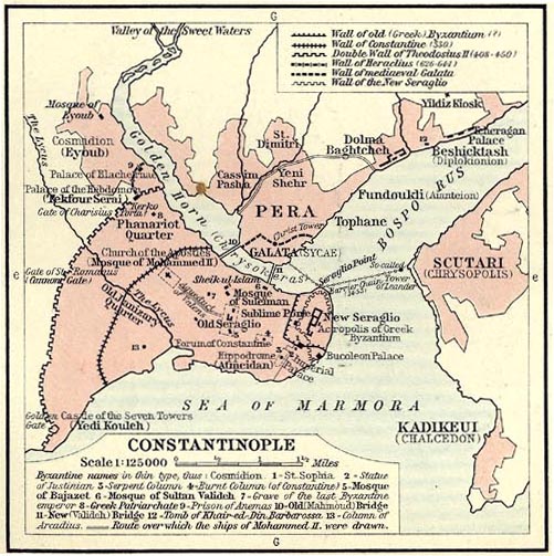
(1911) Shepherd, William R. The Ottoman Empire, 1451-1481 and Constantinople., p. 93
1451 · Wikimedia Commons

The Crimea
1855 · Library of Congress

Carte de l'Empire ottoman (ne différencie pas l'Empire lui-même des états vassaux)
1923 · Wikimedia Commons